


|

|

|

|
Current Report
Thursday, November 9th- Hope, Explanation & Rumors
What a weekend! Unless you've been living under a rock for the past week, you've probably seen pictures of Hoi An underwater from a fairly epic flood. This was quite the event, and while we are first going to look at the weather to come, and look at why this happened, I am also going to spend a bit of time addressing a social issue that reared it's ugly head during this storm as well.
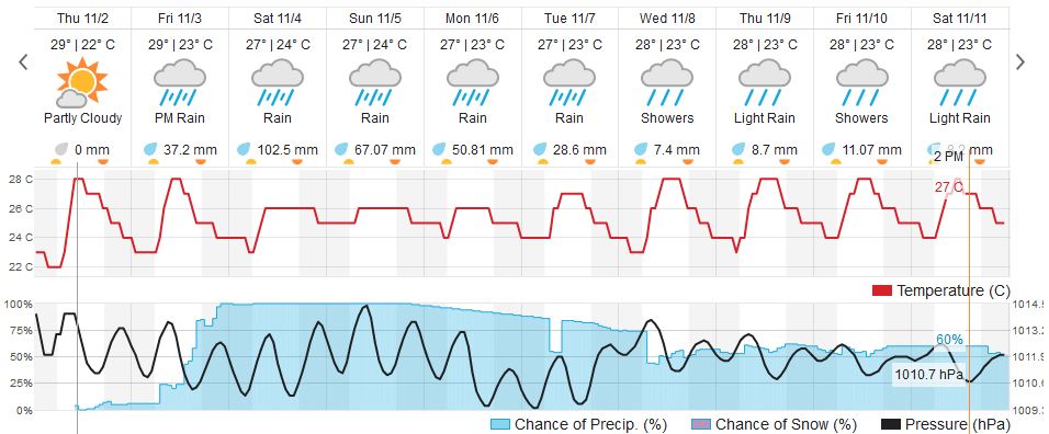
First, the weather. This is the good news. There is relief in sight. Although the rain has diminished greatly, and the water is going down, we aren't completely out of the woods yet. There is still rain forecast for the next few days, although those rains are not supposed to be anything other than simple showers. The biggest news is next week looks to not only be rain-free, but might even bring us some sunshine, a rare novelty these days. The 10-day looks pretty helpful after last week:
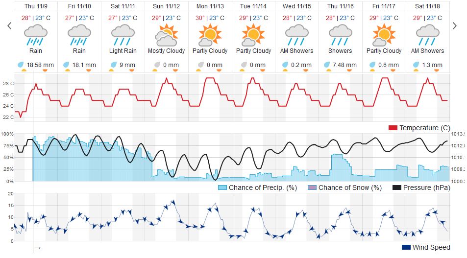
So with a period of nicer weather coming, its now possible to breathe a sigh of relief and begin to assess the damage. A lot of folks have already seen the water recede in their neighborhoods and its likely only a matter of time until the rest of the town dries out. I am still waiting on official confirmation but I think the general consensus is that these were some of the worst floods in the past 20 years, and as soon as I can have some official numbers to share in regards to rainfall and river levels, I will do so. But many people, mostly new arrivals, are curious how this happens? Why does Hoi An get hit so bad and Da Nang doesn't? The answer is in the geography.
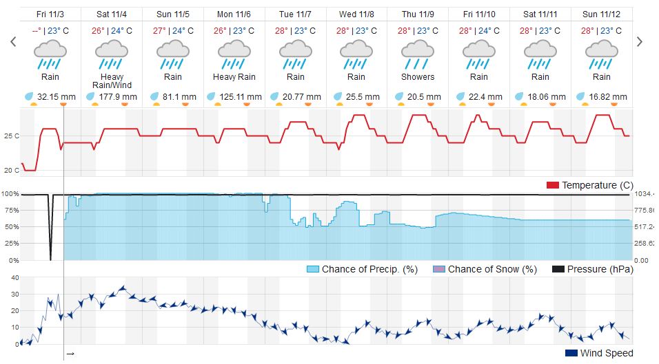
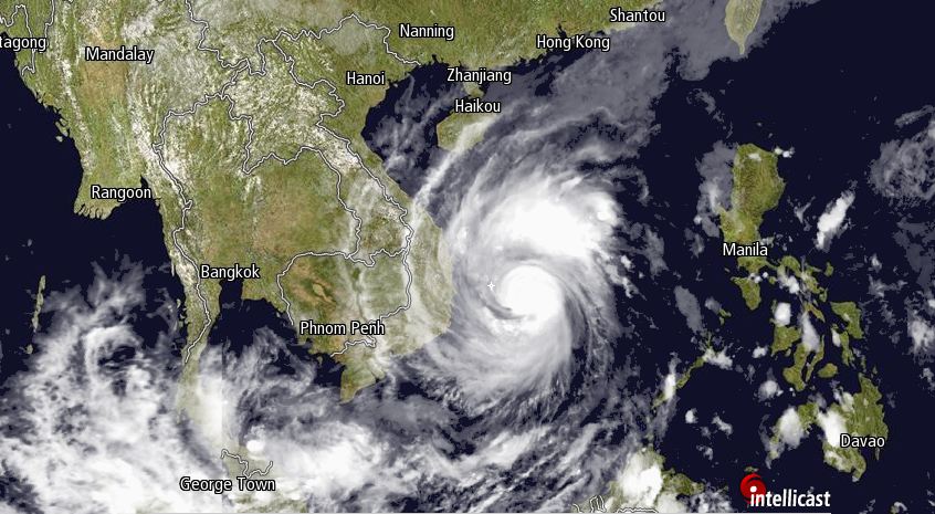
Friday, November 3rd- "strong" Typhoon Damrey
Over the course of last night and through today, Damrey first grew into a "severe" Tropical Storm, before finally crossing the threshold and becoming large enough to be called a typhoon, and has now been categorized as a "Strong" Typhoon. This intensification is not a good thing, and residents of the south central coast of Vietnam should be deep into preparations for a storm landfall. Damrey is likely to be packing winds of over 120 kmh, and has the potential to be a potentially dangerous storm. If you are anywhere between Binh Dinh/Quy Nhon and Phan Thiet/Binh Thuan right now, you should be hopefully be making preparations right now for the impending storm!
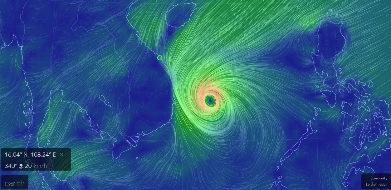
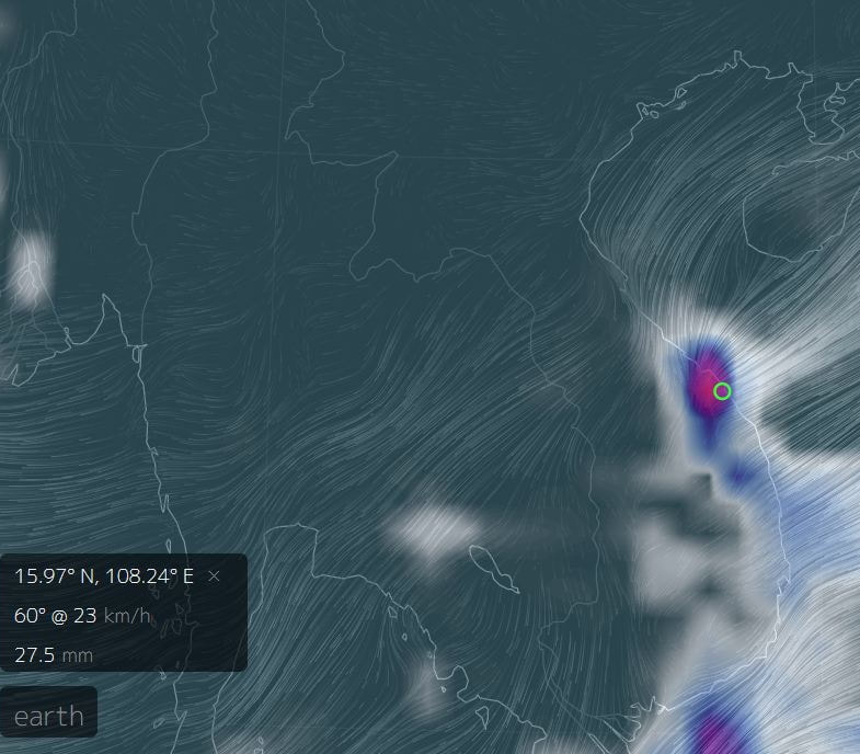
Damrey on approach. Red areas are winds exceeding 60 kmh. Source: www.earth.nullschool.net
|
Damrey is expected to make landfall this evening, sometime likely between midnight and 5 AM. Most of the heavy rain will likely be over the night time hours, leading into the morning. Some areas around could see potentially upwards of 30 mm/hr of rain at times. Here in Da Nang and Hoi An, we will get the same mountain-drive effect as the last tropical system (the now mostly extinct 25W) and although our heaviest rain will likely come around dawn, it will still be quite rainy here tonight and tomorrow. I wouldn't expect the rain to taper off until after the weekend, and even then the early part of next week could still be pretty wet. The biggest wild card is the winds; while we are not likely to receive the full force of the winds like the landfall zone, it is possible our area could get breezy or even gusty at times. If you need to go out tomorrow please be patient and cautious.
|
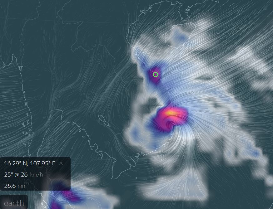
3-Hour Estimated Precip. for 7 AM, Saturday Nov. 4th. Source: NullSchool Earth Map.
|
Check out tomorrow. Fun! Source: www.wunderground.com
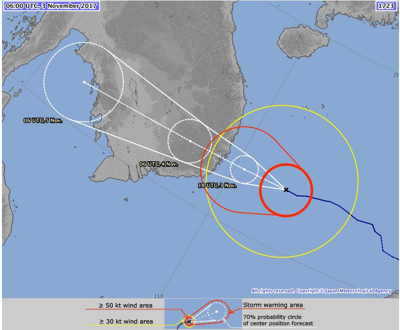
Estimated track for Damrey, from the Japan Meteorological Agency. Source: http://www.jma.go.jp/en/typh/
|
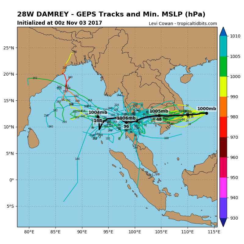
Computer models for Damrey, copyright Levi Cowan, Source: www.tropicaltidbits.com
|
This is a good example of why it helps to pay even a little bit of attention to the weather. All of the local storm forecast services are calling for areas of south-central Vietnam to evacuate and take precautions and stock up ahead of the typhoon. However, thanks to an interesting combination of weather and geography, the area from Hue to Tam Ky is also likely to see some heavy and possibly intense weather. Yet, this is not being mentioned at all and nobody is telling the local people to be cautious. So don't get lulled into complacency, make sure you are stocked up and have some basic supplies ready if you need them, just in case.
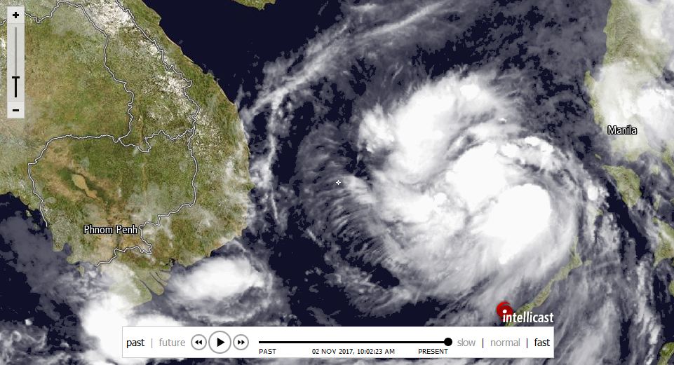
By the time a lot of us wake up tomorrow the storm should have already made landfall and by the later part of the day we might be able to start to get an idea of how much of an impact it has had. So just like Tuesday, get ready for another day inside! I will leave you with the visible satellite image, which although isn't that very helpful from a data standpoint, is helpful in seeing that the storm has assumed a signature rotational shape finally. Thanks for reading! Updates will come as needed.
All photos, charts, maps and graphs are property of their original owners.
Thursday, November 2nd - Tropical Storm Damrey
Fresh off the heels of the impressive rains on Tuesday, we are set to get another round of wet weather this weekend. Just like the rains earlier this week, these are going to be caused by a tropical system making it's way to Vietnam. Unlike the rains from earlier this week, this storm is not going to miss Vietnam, and is expected to make a landfall somewhere along the south-central coast, perhaps near Khanh Hoa or Phu Yen provinces. This storm has been named "Damrey" by the Japan Meteorological Agency, and it is time to start paying attention to it.
Visible satellite image. Source: www.intellicast.com
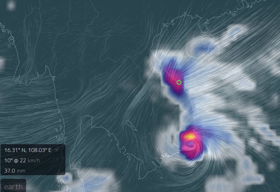
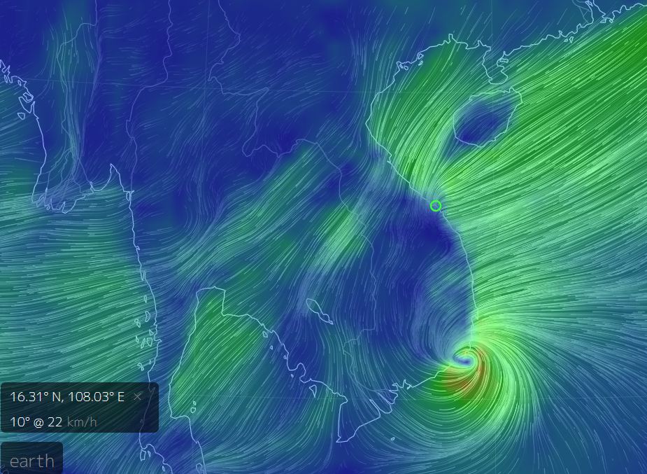
Although the storm is projected to make landfall south of us here in Da Nang and Hoi An, we do need to be concerned, because just like the previous rains, the process of "Damrey" connecting with those wet and cold autumn winds coming our way from the seas up near Taiwan is going to mean a lot of moisture is going to be drug over our local area quite roughly. Thanks to the mountains in our area- Bach Ma, Son Tra, Ba Na, Charlie Ridge, the mountains of Nam Tra My and Ngoc Linh- these moisture streams get ripped open and heavier rain can fall here as opposed to anywhere else other than the landfall site itself. Check out the image on the left to get a better idea- the main impact site is obviously the site of the heaviest rain, but the other area of "heavy to intense" rainfall is the Da Nang/Hue area. The image on the right shows how thanks to Hai Nan Island and a combination of geography and current wind conditions are are almost "focusing" some of the winds right onto us. Da Nang is the small green circle in both images.
|
|
L: Estimated 3 Hour Precipitation Average and R: Estimated Wind Speed and Direction, both for 10:00AM on Saturday, Nov 5th. Source: http://earth.nullschool.net.
For us, it means the rains are going to hit hard and heavy, starting on Friday night and progressing into Saturday. It could potentially rain for a few days after that as well, although they shouldn't be anywhere near as hard or heavy as Wednesday. You can see on the 10-day forecast below what they are expecting us to get.
Source: www.wunderground.com
The storm has had a bit of an interesting track. Earlier this year, during Doksuri, and Khanun, we were hoping the storms would go north, so that it wouldn't hit us. Every time they jogged a bit to the south we got a little worried. Now, we are seeing a bit of the opposite; the storm was originally forecast to go well south of the entire country, perhaps following the same track as the unnamed Tropical Depression that brought us Monday's rains, but it has steadily defied those projections and continues to maintain a more true west direction as opposed to shifting south. Now, with each jog north, we need to pay attention a little more. And while a direct landfall in our area is not likely at this time, it goes without saying that just a small deviation in projected track could put us more in the direct impact zone, which would give us not only rains, but more powerful winds. You can see the JMA expected track on the left and the TropicalTidbits track models on the right.
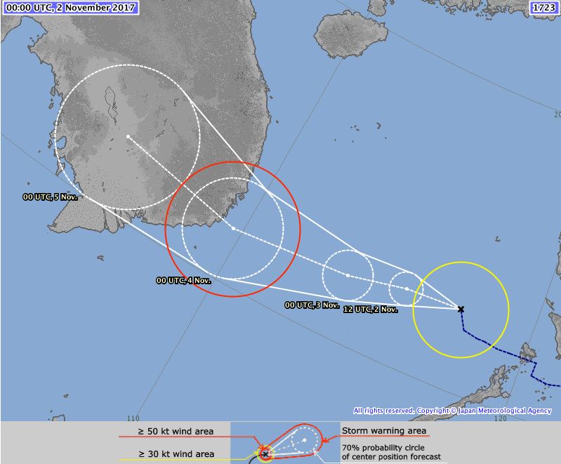
Source: http://www.jma.go.jp/en/typh/
|
Source: Levi Cowan, TropicalTidbits, www.tropicaltidbits.com
|
I am watching the storm as it approaches but it goes without saying expect a very wet Saturday. Might not be a good idea to stock up on some supplies beforehand and be prepared to ride out some rains. This is unfortunate timing with APEC coming, but hopefully this system will be out of here before stuff really gets going. However, some of you out there do need to be concerned, specifically:
|
+ Hoi An - Be prepared for more flooding along the Thu Bon River as the streams in the mountains drain out.
+ Nha Trang/Tuy Hoa/Central Coast - You should be preparing right now for the storm! + Low Lying Areas - Just use general caution as all area rivers are likely to rise significantly in the next few days. |
Otherwise, keep the rain jacket and umbrella ready as always, they've sure been getting some use here lately, huh? Stay tuned for more updates.
All charts, maps & diagrams are property of their original owners.
Tuesday, October 31st
|
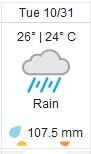
Happy Halloween everyone! Hope you are all staying dry out there in this nice rain. Big shout out to my boy Byron Kerr for driving 15 hours from Savannakhet to Da Nang, through some of this torrential rain no less! That's a hefty feat anyway you look at it. Glad you made it Byron! As for the weather, this will be a fairly quick one. If you are just waking up it has been raining like this since last night, and its not supposed to let up much all day into tomorrow. Indoor plans would be very helpful today. The forecast for the heavy rains that I posted yesterday have proven surprisingly accurate. Compare the photo to the right with the one in the post below and you can see just how similar they are. |
3-Hour Precip. Forecast. Source: earth.nullschool.net.
|

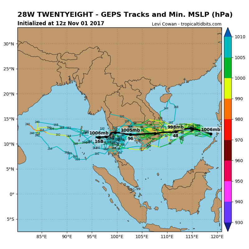
Image property Levi Cowan. Source: https://www.tropicaltidbits.com/storminfo/96W_geps_latest.png.
|
In addition to the rain, the other thing that needs mentioning is the Low Pressure Area (LPA) that is harassing the Philippine Islands as I write this. This LPA is forecast to turn into a tropical depession in the coming hours. The forecast models have been all over the place for this one; yesterday most of the models had it tracking west-southwest, either making landfall between Mui Ne and Ca Mau, or missing Vietnam completely and going into the Gulf of Thailand, following the storm that is down there right now. However, the newest models have it making landfall anywhere between Sai Gon and Binh Dinh, so where it will end up is still in question. The one good thing is it is fast moving, which will help prevent it from growing really large, but it is conceivable we could see another decent round of rains from this one as well. As always, I will continue to provide updates as needed. |
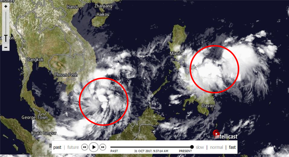
Visible satellite image of both the Tropical Depression and the LPA. Source: www.intellicast.com.
Finally, during a discussion with Randy from Randy's Book Xchange in Hoi An, it got me curious to look at what our rainfall for October is at now. I had looked a couple weeks back and we were decidedly below average, and even with this rain today we are still going to finish the month WELL below average. As it stands right now, with about 12 (very rainy) hours of October left, we are sitting at ~170 mm for the month. Consider that the average for October is around 615 mm and you can see it has been a very dry rainy season thus far. That being said, it will be interesting to see what happens with this next storm thats coming up as well. Perhaps a drier October means a wetter November? Who knows. Until then stay dry and have a good one out there.
All images, models and maps are copyright of their original creators.
Monday, October 30th
Like I said on my earlier Facebook post, things are about to get pretty wet in the Da Nang area. Thanks to a small tropical depression hanging off the southeast coast of Vietnam, we are in line to receive some good moisture over the next few days. Let's take a look at what is going on and what to expect.
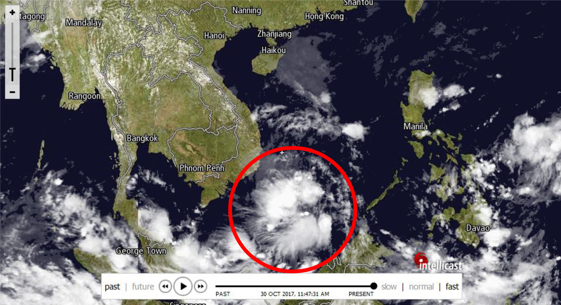
Unnamed tropical depression southeast of Vietnam. Source: www.intellicast.com.
|
The storm itself isn't so big and bad. It doesn't have a defined eyewall, and the rotation is so minimal that weather sources are only reporting a maximum of 30 knot winds. That's no worse than a breezy spring day. So its not a big or destructive storm, and it's track is one over open water for the most part. The biggest issue with this storm is it has tapped into some of the autumn moisture north of us, and in it's process of drawing that moisture down and into itself that moisture is going to get drug over us. Thanks to the mountains in this part of Vietnam, it will draw a lot of that moisture out of the sky, which will turn translate to rain for us as long as that "feeding stream" remains in place.
|
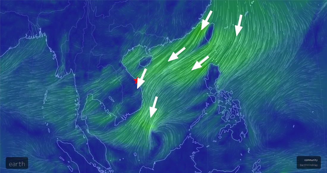
NullSchool Earth Map view of winds associated with the storm. Source: https://earth.nullschool.net/.
The storm is moving slowly to the west, and as it moves further and further west, it is going to eventually disconnect it's feeding streams, at which point our rains will subside a little. Supposedly the rains are going to start later today, either this afternoon or evening. Some of you may have already seen some rain in the forecast area, so its just a matter at this point of when it resumes. The water is there, and it WILL rain, the biggest question now is just when will it start. Wunderground has a 100% chance of rain for the entire 24 hour period tomorrow and into Wednesday before it finally tapers off.
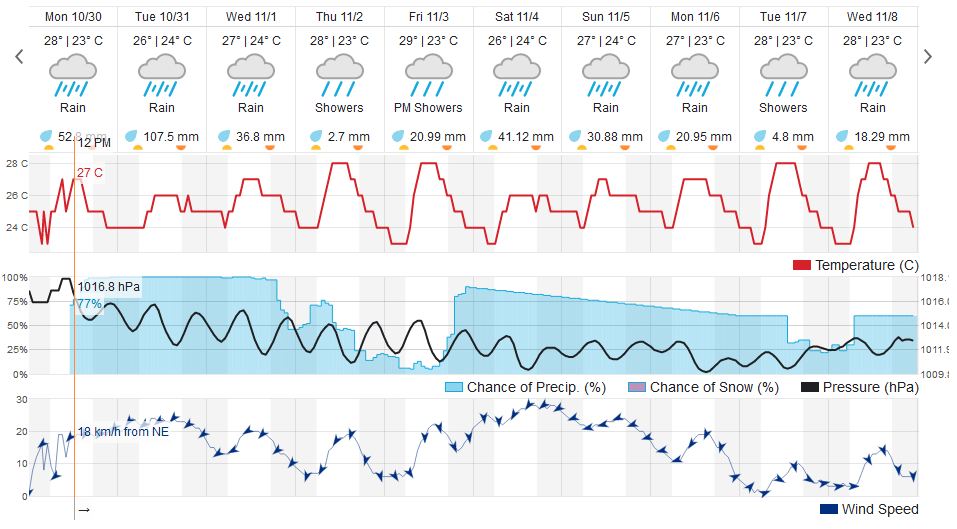
Wunderground 10-day forecast. Source: www.wunderground.com.
|
My guess is today only sees a little rain here or there, at least until this evening, but I bet overnight the rains move in big time and it continues into the next few days. Tomorrow (Tuesday) could actually see some pretty heavy rains at time; the NullSchool Earth Map has forecasted it to rain as heavy as 10 mm an hour at times, with a 100+ mm forecast for the day. Keep that raincoat and umbrella handy over the next few days, you are going to need it. I will post another update after this rain passes with what is coming next. Thanks for reading!
|
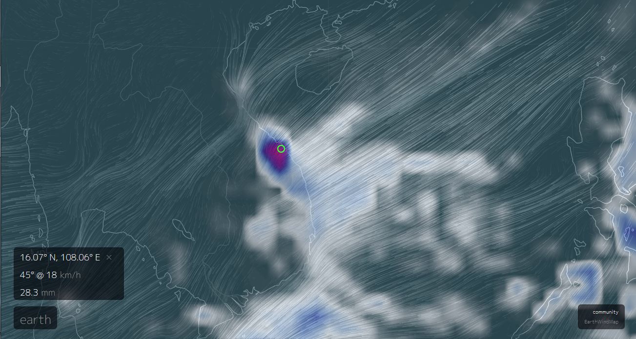
3 Hour Precipitation Forecast for 10:00 to 13:00, Tuesday, October 31st. Source: NullSchool Earth Map.
|
All charts, maps and graphs are property of their original creators.
Friday, October 20th
1. Sun?
2. Storms
3. Rainy Season and Rains
2. Storms
3. Rainy Season and Rains
Source: NullSchool Earth Map, https://earth.nullschool.net/
1) Sun?
Although it may be raining on Friday morning as I write this, there is a small window of sun that is supposed to appear today, Friday, and carry through tomorrow and possibly into Sunday. While I wont guarantee a random shower isn't going to happen, it does look things might actually be clear for a couple days. So if you have been feeling a bit cooped up, or have been missing the sun lately, tomorrow (Saturday) will be the day to get out and go play in the sun.
2) Storms?
There isn't much risk from any storms right now. The only storm out there in the basin is Typhoon "Lan", which is moving north and is heading towards Japan, not us. This storm system is so massive that it has pulled in two smaller LPAs near it and is currently ramping up to be a very large, very powerful typhoon. This is not good news for Japan, but for us it's actually helpful as not only does it mean we have no imminent storms, but we don't have to worry about any in the mid-term either. Still too early to say we are out of the season yet, though.
Source: Wunderground, https://www.wunderground.com/forecast/vn/danang-international?cm_ven=localwx_10day
3) Rainy Season and Rain
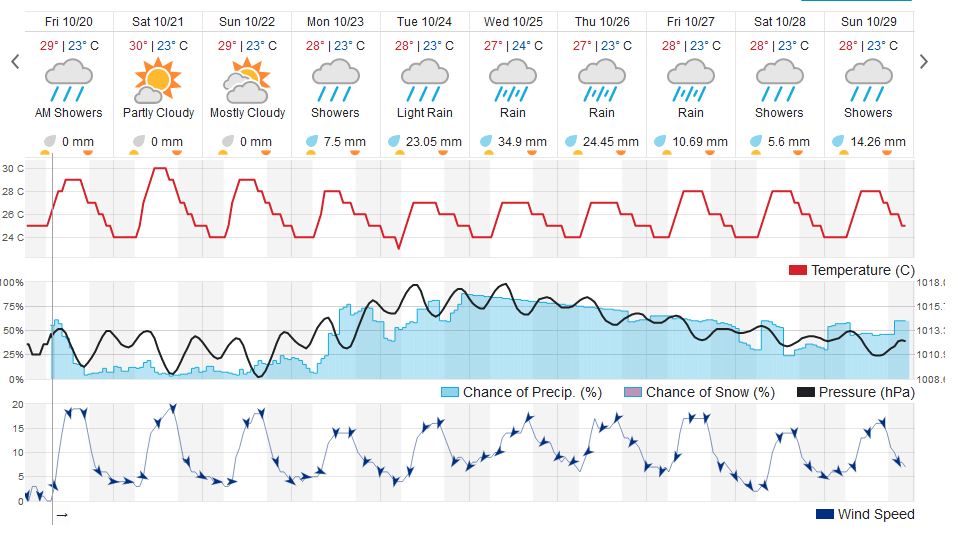
Looking at the forecast over the next 10 days, we can see a big chunk of rain coming up soon. John Gnoni was saying he felt like there hadn't been much rain this rainy season, and I tend to agree with that, so I went to find some data to back that claims up. The results are actually pretty shocking. We were far below average for total rainfall for September, and through 19 days in October we are FAR below the monthly average to this point. So while the rainy season could be far from over, it is worth noting that we are now over halfway through our rainiest months, so this "rainy season" hasn't been so bad at all. The numbers are a bit shocking:
Looking at the forecast over the next 10 days, we can see a big chunk of rain coming up soon. John Gnoni was saying he felt like there hadn't been much rain this rainy season, and I tend to agree with that, so I went to find some data to back that claims up. The results are actually pretty shocking. We were far below average for total rainfall for September, and through 19 days in October we are FAR below the monthly average to this point. So while the rainy season could be far from over, it is worth noting that we are now over halfway through our rainiest months, so this "rainy season" hasn't been so bad at all. The numbers are a bit shocking:
September Average: ~300 mm
September 2017: 149 mm
October Average: ~615 mm
October 2017: ~150 mm [through Oct. 19th]
September 2017: 149 mm
October Average: ~615 mm
October 2017: ~150 mm [through Oct. 19th]
So, keep the raincoat in the bike, but would also suggest some tentative and cautious optimism for today and tomorrow (and maybe even Sunday??) to take advantage of this nice break in the rain. Thanks for reading!
All maps, charts, and images copyright their original owners.
Wednesday, October 18th
1) Tropical Systems
2) Rain?
3) Outlook
2) Rain?
3) Outlook
Welcome to the new Da Nang Weather Report! I will now be posting my updates here, at least for a while until a new system can be worked out. Many thanks to all of you who sent messages of support, I do appreciate it and thank you for them! Now, let's get to the weather!
1) Tropical Systems
1) Tropical Systems
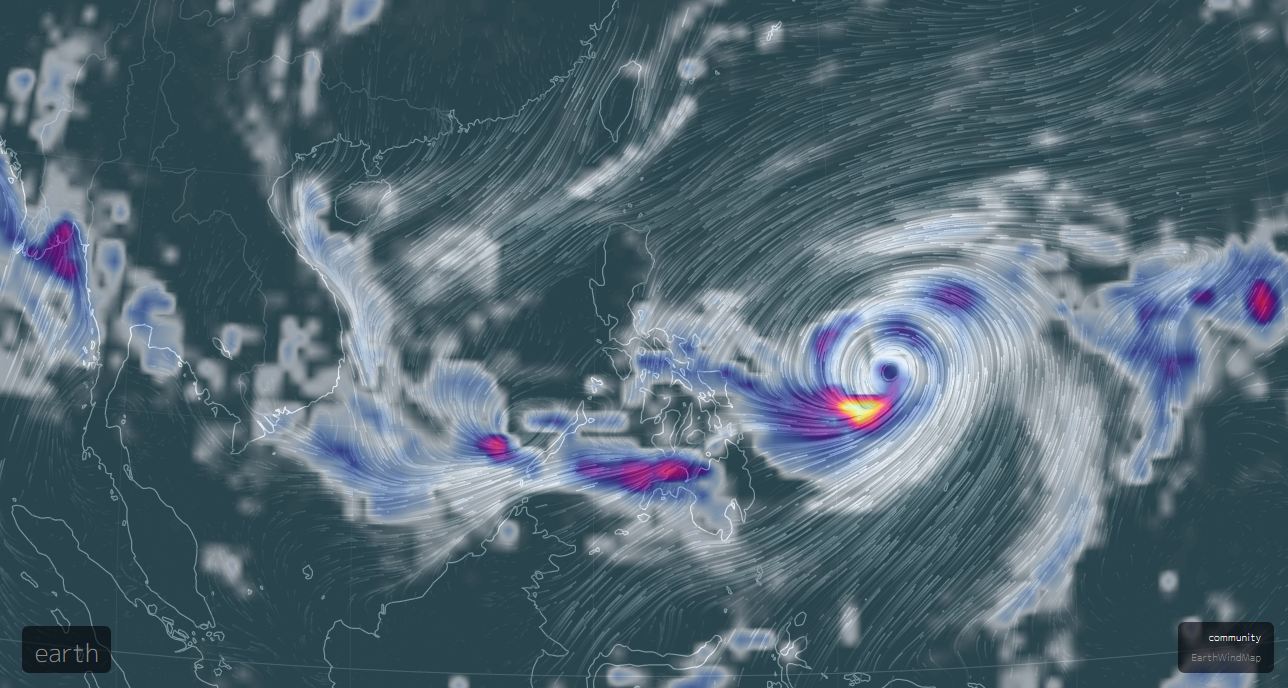
Source: NullSchool Earth Map, https://earth.nullschool.net/
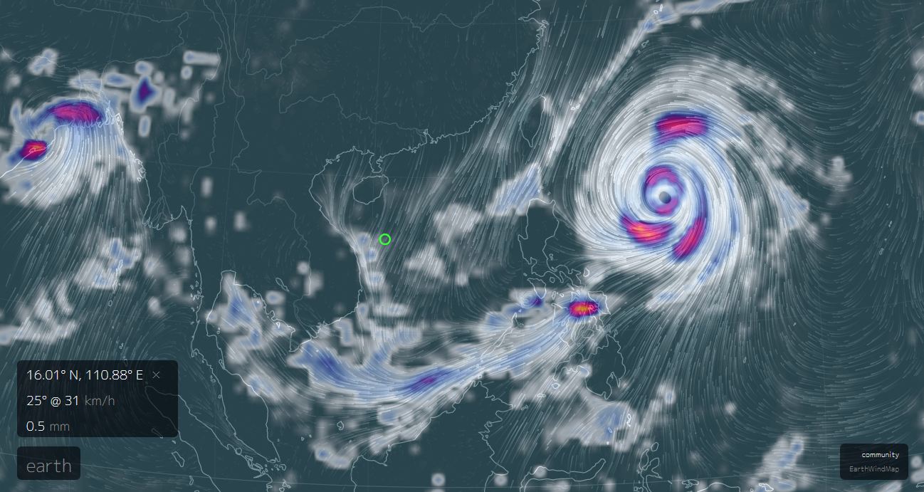
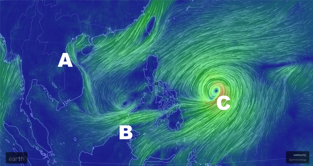
The EarthMap has not just one, but THREE low pressure areas (LPAs) right now in the "Western Pacific Basin". A is the remains of what was Typhoon "Khanun", which, despite mostly dissipating, is still causing problems for provinces farther north thanks to the winds and rains it created that just don't seem to be clearing out yet. B is the small, as-yet-unnamed system that is lurking in an unusual spot for this time of year, and C is Typhoon "Lan".
First, the remains of "Khanun". The storm was broken apart as it made it's interesting swing around Hainan Island, and although the rotation is gone and the storm is basically no more, the remaining winds and rains are causing problems for the already-battered north central provinces, including Son La, Hoa Binh, Ninh Binh, Thanh Hoa and more. The remains of this are what are and what will be driving our rains for the next few days (see below). These winds and rains will eventually die down, but at this point its a matter of guessing how long that will take.
First, the remains of "Khanun". The storm was broken apart as it made it's interesting swing around Hainan Island, and although the rotation is gone and the storm is basically no more, the remaining winds and rains are causing problems for the already-battered north central provinces, including Son La, Hoa Binh, Ninh Binh, Thanh Hoa and more. The remains of this are what are and what will be driving our rains for the next few days (see below). These winds and rains will eventually die down, but at this point its a matter of guessing how long that will take.
|
Second, the unusual LPA currently hanging off Palawan. This storm is unusual in two ways: it's origin, and it's direction. Although it isn't unheard of for storms to form in the East Sea basin, they typically do so much more north, closer to northern Luzon, or further west towards Vietnam. What is really interesting is where the storm is expected to go; the fine folks at www.tropicaltidbits.com have projected this storm to first head east, crossing the Philippines, and then turning north and heading for Japan. Most storms that cross the Philippines this time of year do so going west across the islands, not east.
Finally, we have Typhoon "Lan", which is spinning off the east coast of the Philippines, and looks to move north towards Okinawa and Japan in a classic Western Pacific typhoon. Neither this nor the LPA off Palawan pose us any danger whatsoever, so we really don't need to pay attention to them. |
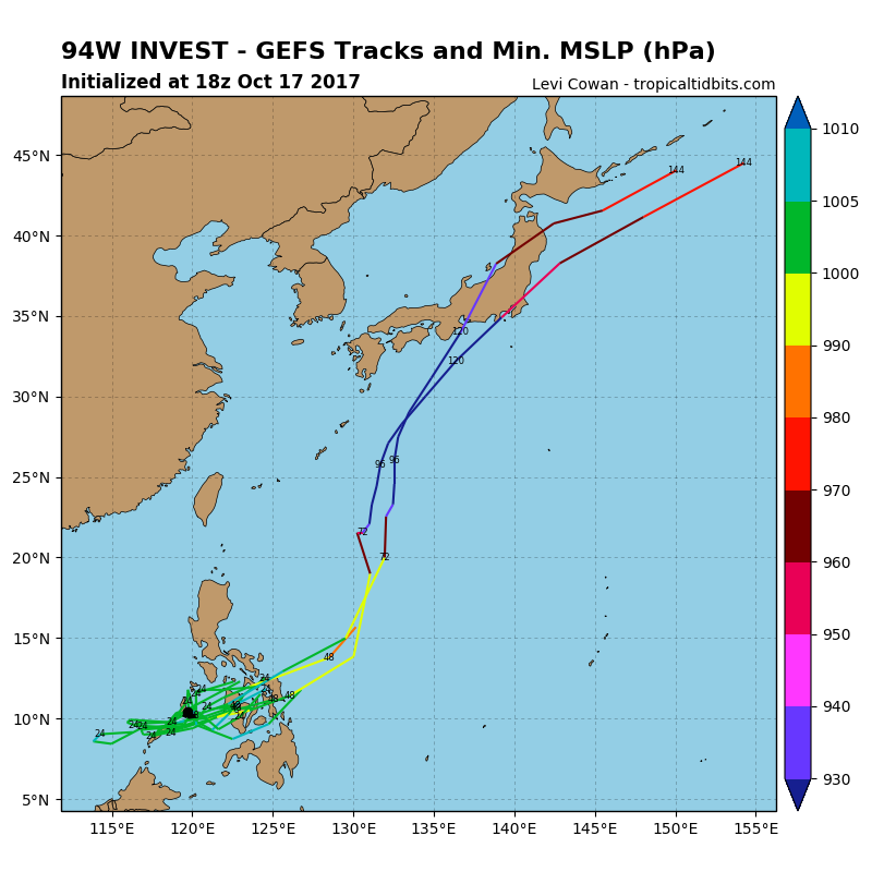
Map courtesy www.tropicaltidbits.com, author Levi Cowan.
|
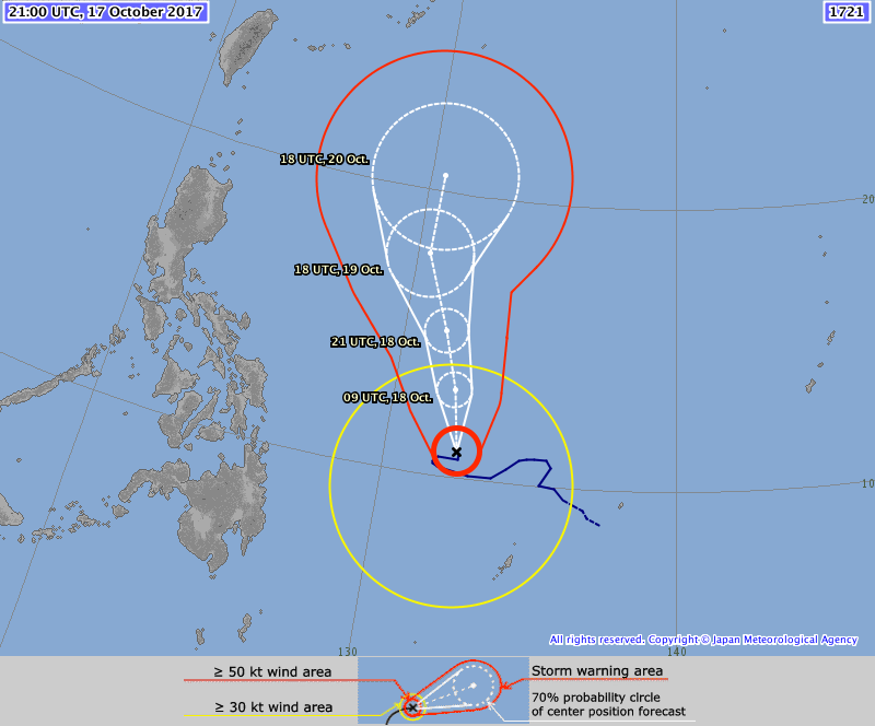
Tracking map courtesy Japan Meteorological Agency, http://www.jma.go.jp/en/typh/
|
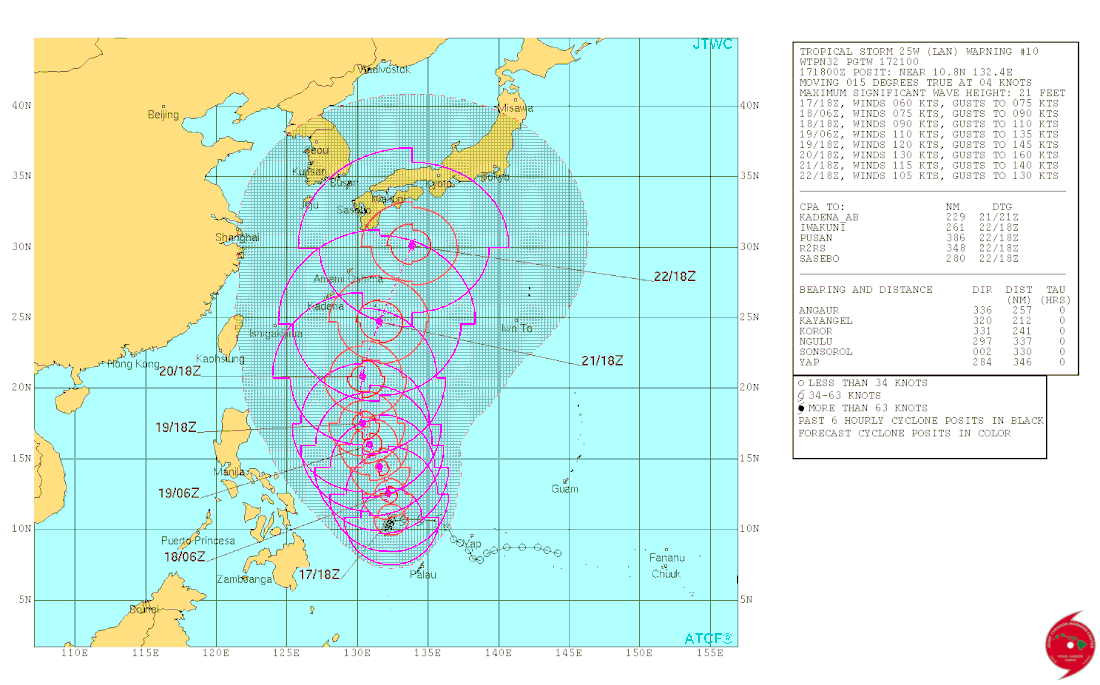
Tracking map courtesy JTWC, http://www.usno.navy.mil/JTWC/
|
2) Rain?
As you can see below on the 3-Hour Precipitation Forecast, there is a large area of rain that stretches down the north-central Vietnamese coast right now. It's raining quite heavily just off the coast out in the sea, and though here on the coast its quite a bit less, we are still in the "shadow" or fringe of the rain, which means we are still going to see some showers as long as those rains hang out. These rains are definitely the leftover moisture from "Khanun", driven by and encouraged by some strong winds from the north, cool autumn winds from inland China. I've also included the current 10-day forecast from www.wunderground.com, which shows that we will be plagued by the showers for a while yet to come, and with an exception of Friday and Saturday, things are definitely looking like rainy season here. Sorry to John Gnoni but I think we've still more to come yet! Pack that rain coat and umbrella because there's always going to be a chance for rain on days like we are supposed to have for the next bit of time.
As you can see below on the 3-Hour Precipitation Forecast, there is a large area of rain that stretches down the north-central Vietnamese coast right now. It's raining quite heavily just off the coast out in the sea, and though here on the coast its quite a bit less, we are still in the "shadow" or fringe of the rain, which means we are still going to see some showers as long as those rains hang out. These rains are definitely the leftover moisture from "Khanun", driven by and encouraged by some strong winds from the north, cool autumn winds from inland China. I've also included the current 10-day forecast from www.wunderground.com, which shows that we will be plagued by the showers for a while yet to come, and with an exception of Friday and Saturday, things are definitely looking like rainy season here. Sorry to John Gnoni but I think we've still more to come yet! Pack that rain coat and umbrella because there's always going to be a chance for rain on days like we are supposed to have for the next bit of time.
Map courtesy of NullSchool Earth Map, https://earth.nullschool.net/
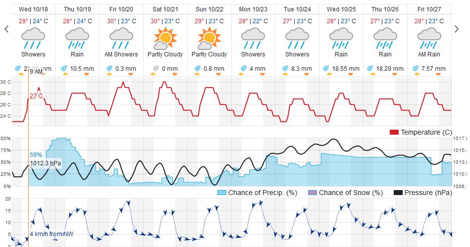
Forecast courtesy of www.wunderground.com
3) Outlook
For now, like I said earlier, it sure does look like rainy season out there. We should count our blessings; so far this one hasn't been too bad at all, as they can be much worse. We will just have to see how long these rains continue. As for temperatures, while it has been dropping down lately, highs for the day times are still fluctuating between 25 and 30, which is still pretty damn nice. I know a lot of the locals have been running for their jackets lately but for most of us expats I think we can agree its still plenty warm enough out there. The real true winter winds, the coldest of the year for us, haven't started coming down from Siberia in full force yet, so as long as those hold off we should still enjoy those temps.
Finally, it's still too early to say we are out of the woods for tropical storms yet, but this last storm, "Khanun", was very interesting. All the conditions looked fairly prime for it to make a track for us, and yet, it completely missed us and took a really strange path instead. That should give us all a little bit of hope that maybe the season could wind down without a major storm, but its still too early to say that, so, the wait and watch continues.
Thanks for reading!
All maps, charts, and images copyright their original owners.
Christmas Eve, 2016 Report
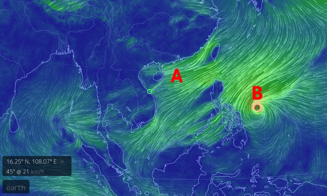
For Xmas Eves we've got two things to discuss (Pic 1):
A) Winter
B) Typhoon Nock-ten
A) Winter- Hope you are all enjoying our fine winter! Consider this a friendly reminder that all the stuff that's been going on- the chilly winds, the cold drizzle, the monotonous grey, the flooding- these are all totally normal parts of the "winter" season here, and the "winter" season is totally normal in itself. Every year around this time there always seems to be a few people bitching and moaning about how Da Nang shouldn't be cold and that "its a beach town" and generally whining, please remember this is totally normal. If you want 12 month, year round beach beauty, consider Thailand or Indonesia. For now, Winter continues.
B) Typhoon Nock-ten- This is a powerful system, and it's looking like it's going to cause some Christmas damage to the Philippines before it heads west into our basin. Right now it's hanging out as a Category 2/3 typhoon. However, let it be known, THIS IS NOT A DANGER TO US. Again, this storm does not need to be a worry for us here in Da Nang! The reason for this is the same reason we are getting a good winter blast right now- the Northeast Flow is just too damn strong and it's going to go to the south and west of us. (pic 2)
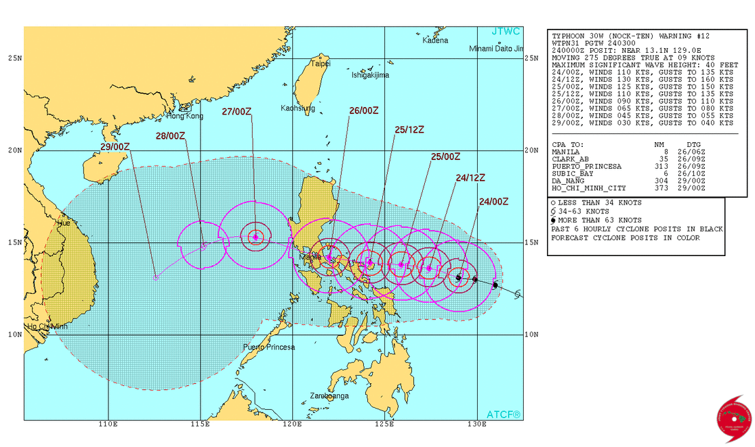
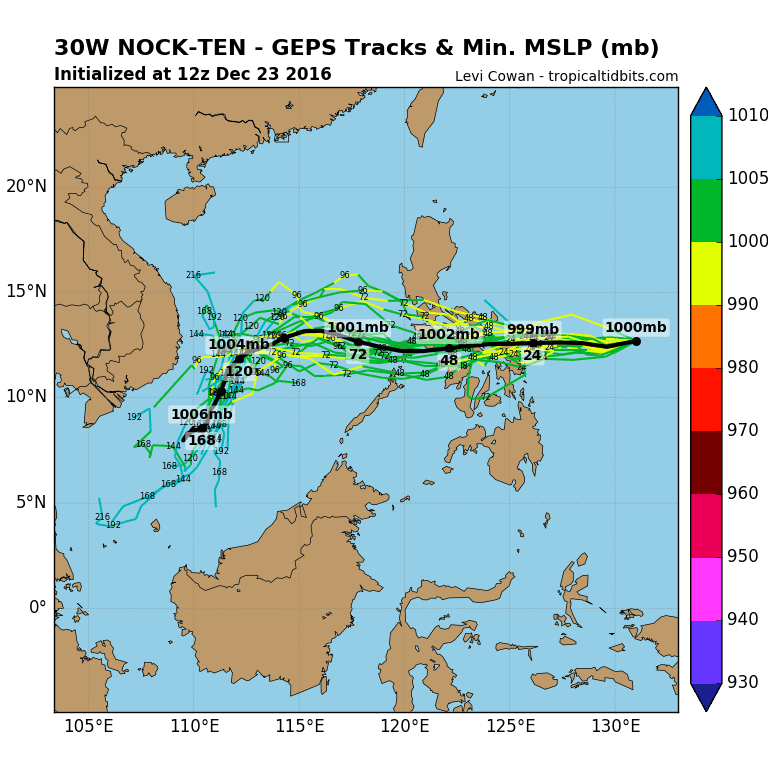
At this point there's two possibilities: If the storm tries to go north it will get destroyed by the wind shear between the NE Flow and the tropical winds, and if it does maintain its structure, it will instead be forced southwest, along and off the coast to the south near Mui Ne and HCMC. A smaller storm took a similar track a couple weeks ago. (pic 3)
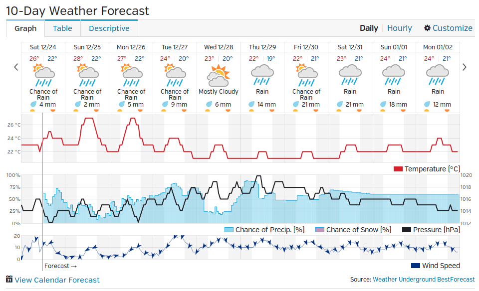
If this does happen, then we will get some rains and winds and it could be kind of shitty for a few days. But, we wont be getting a landfall or a direct hit. If you look at the 10 day forecast (pic 4) you'll notice there's not much rain out there. So although Xakai has (yet AGAIN) raised the alarm and worried a bunch of people there actually is very little worry here.
Hope everyone isn't going too crazy with the winter so far- remember, we've still got a couple months yet of very likely similar weather yet. Everyone stay warm out there and try to keep the boredom away!
For Xmas Eves we've got two things to discuss (Pic 1):
A) Winter
B) Typhoon Nock-ten
A) Winter- Hope you are all enjoying our fine winter! Consider this a friendly reminder that all the stuff that's been going on- the chilly winds, the cold drizzle, the monotonous grey, the flooding- these are all totally normal parts of the "winter" season here, and the "winter" season is totally normal in itself. Every year around this time there always seems to be a few people bitching and moaning about how Da Nang shouldn't be cold and that "its a beach town" and generally whining, please remember this is totally normal. If you want 12 month, year round beach beauty, consider Thailand or Indonesia. For now, Winter continues.
B) Typhoon Nock-ten- This is a powerful system, and it's looking like it's going to cause some Christmas damage to the Philippines before it heads west into our basin. Right now it's hanging out as a Category 2/3 typhoon. However, let it be known, THIS IS NOT A DANGER TO US. Again, this storm does not need to be a worry for us here in Da Nang! The reason for this is the same reason we are getting a good winter blast right now- the Northeast Flow is just too damn strong and it's going to go to the south and west of us. (pic 2)
At this point there's two possibilities: If the storm tries to go north it will get destroyed by the wind shear between the NE Flow and the tropical winds, and if it does maintain its structure, it will instead be forced southwest, along and off the coast to the south near Mui Ne and HCMC. A smaller storm took a similar track a couple weeks ago. (pic 3)
If this does happen, then we will get some rains and winds and it could be kind of shitty for a few days. But, we wont be getting a landfall or a direct hit. If you look at the 10 day forecast (pic 4) you'll notice there's not much rain out there. So although Xakai has (yet AGAIN) raised the alarm and worried a bunch of people there actually is very little worry here.
Hope everyone isn't going too crazy with the winter so far- remember, we've still got a couple months yet of very likely similar weather yet. Everyone stay warm out there and try to keep the boredom away!
Source: NullSchool Earth Map, https://earth.nullschool.net
|
Source: Tropical Tidbits, www.tropicaltidbits.com
|
Source: Tropical Tidbits, www.tropicaltidbits.com
|
Source: Wunderground, www.wunderground.com
|
