
Skip to the Interactive Map!
***** A note on names: It's been brought to my attention that some people have begun calling this the "Goat's Penis" River, because "cu" is a slang word in Vietnamese for a dick or penis. However, the word for goat is "de", whilst the river's name is "Đê". So to be clear; this river is NOT called the "Goat's Penis" River, despite what junior-high school level joke you may have heard. The name "Cu Đê" roughly translates to
"youngest boy whos name is Đê", so that is the correct name.
"youngest boy whos name is Đê", so that is the correct name.
|
As Vietnam modernizes and moves from 3rd world country to developing country, there are bound to be some inevitable losses along the way, in the form of social, cultural, and physical changes. It's not uncommon for ethnic tribes to lose their languages and their ways of life. It's not uncommon to lose localized cultural identities as all citizens of a country are pushed together and told to have solidarity with one another. Some places suffer from major impacts to the ecosystem and animal populations, and others get physically changed or even outright destroyed. This river valley is a good example of a place that is on the brink of a major change, one that might not be so great. |

Cows & mountains.
|
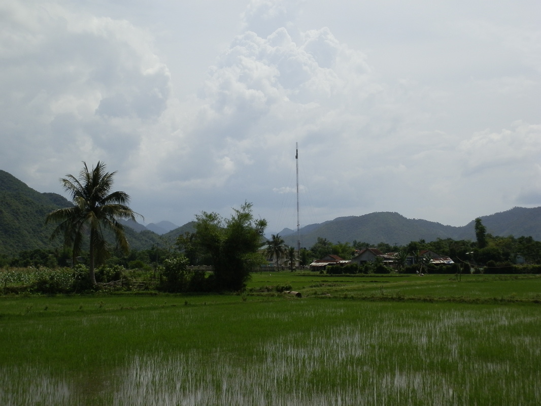
Even as recently as 2013, this was but a sleepy dead-end valley that was rich in beauty, charm, and local character, and very short on active development. Slow, sleepy villages with cows freely roaming, and empty rice paddies were the name of the game. There (for now) are no major restaurants or hotels. But, this valley will very soon be play host to a major four-lane highway running between Da Nang and Hue. The highway will be routed through the foothills, and not on the valley floor itself in the lower section of the valley. However, higher up in the narrower canyon things will be very different. So while it remains to be seen just how badly the impacts will be felt, it goes without saying that the new highway will forever alter this valley and the lives of the people within it.

South Fork of the Cu De River.
The Cu De Valley itself can be divided into two sections: the Upper Valley, and Lower Valley. The Lower Valley is broad, flat, and contains magnificent and expansive rice paddies beneath the soaring peaks of the Truong Son Mountains. The river is slow and placid, and winds peacefully back and forth across the valley. Further up, the valley narrows dramatically, and above here is the Upper Valley, which is more of a classic river canyon than a true valley. A short ways past this first constriction is the confluence of the North Fork and South Fork of the Cu De River. These two rivers flow down parallel valleys (likely horst and graben valley blocks) for several kilometers before their confluence, and while passage is blocked up the North Fork of the Cu De, you can drive a short ways up the South Fork. Of course, this may all change in the future as the new four-lane highway brings modernity and access to the Cu De River corridor.
 |
 |

Truong Son Range & Suoi Cay Cascades.
South Valley Road
|
The main road up the Cu De Valley runs along the south shore of the river. The road starts northwest of Da Nang, along the old Ba Na Hills road, and wanders through some small suburban villages around the town of Hoa Lien. One of the original villages that was here before Da Nang, this small town spreads out along the road for a handful of kilometers.
Eventually you will cross under the Highway 1A bypass, and then you will be in the Cu De Valley proper. The road meanders along for a few kilometers, past some small cemeteries and houses. The first bridge across the Cu De can be found here. In this lower part of the valley, there is a small open park between the hills, and in the middle of this valley is the small town of Hoa Bac. While "Hoa Bac" extends all the way up the valley, this small core is the original village, and it has a pretty incredible backdrop as far as small towns go. |

"Old" Hoa Bac.
|

Original Hoa Bac.
|

Abandoned house near Hoa Bac.
|
After Hoa Bac, you turn a corner and enter one of the more impressive places around Da Nang. The Cu De comes out of it's narrow upper valley, and opens up into a major park surrounded on all sides by mountains and hills. The Truong Son Range rises on the north side of the valley like a green wall, with the multiple-tiered cascade of the Suoi Cay emerging from the green folds of the mountains. The valley bottom is flat and green, some of it having been turned over to crops, while other areas remain wild and open. The mountains that separate the Cu De from the valleys that make up the headwaters of the Song Vang rise to the south, and thanks to a neat bend of the Cu De River itself, it's impossible to see just how close you are to the sea here.

Upper end of the Lower Valley.

|

|
Clockwise from Top Left: Small waterfall; South Valley Road; Lower Valley; Suoi Cay Cascades.

|

|
At the end of this valley, the road and river both make an abrupt turn to the south, and you enter into a much narrower Upper Valley. Here the mountains on either side become smaller, but the valley itself is a much tighter place, just a few hundred meters wide, rather than the more expansive and wider Lower Valley. The turn is quite abrupt. The road follows the river up for quite a ways beyond this. At one point the road crosses a creek and then enters a new town. This town is still part of "Hoa Bac", so I like to call this settlement "New Hoa Bac". Just past Hoa Bac the road cross the South Fork of the Cu De just above it's confluence with the North Fork of the Cu De. The dramatic gap through which the North Fork cuts is beautiful, ominous, and inviting all at the same time.

Post Office Bridge.

"New" Hoa Bac.
|

Traditional wood house.
|
After "New Hoa Bac", the road comes over a small hill and drops down to the confluence of the North and South Forks of the Cu De. The North Fork comes spilling out of the mountains in a dramatic fashion, cutting through the small ridge that separates the two forks and their respective valleys. This area was once targeted for development as part of a massive hydroelectric project, but thankfully that project seems to have been pushed back for now. The road crosses the South Fork just above this confluence, offering a great view of some of the rapids along the South Fork. There is a small village just after this as well, complete with a goul (communal house) and some traditional wood-built buildings.

Confluence of the North & South Forks. The North Fork spills out of the valley in the center, and and main Cu De flows out of frame right.
South Fork Valley
|
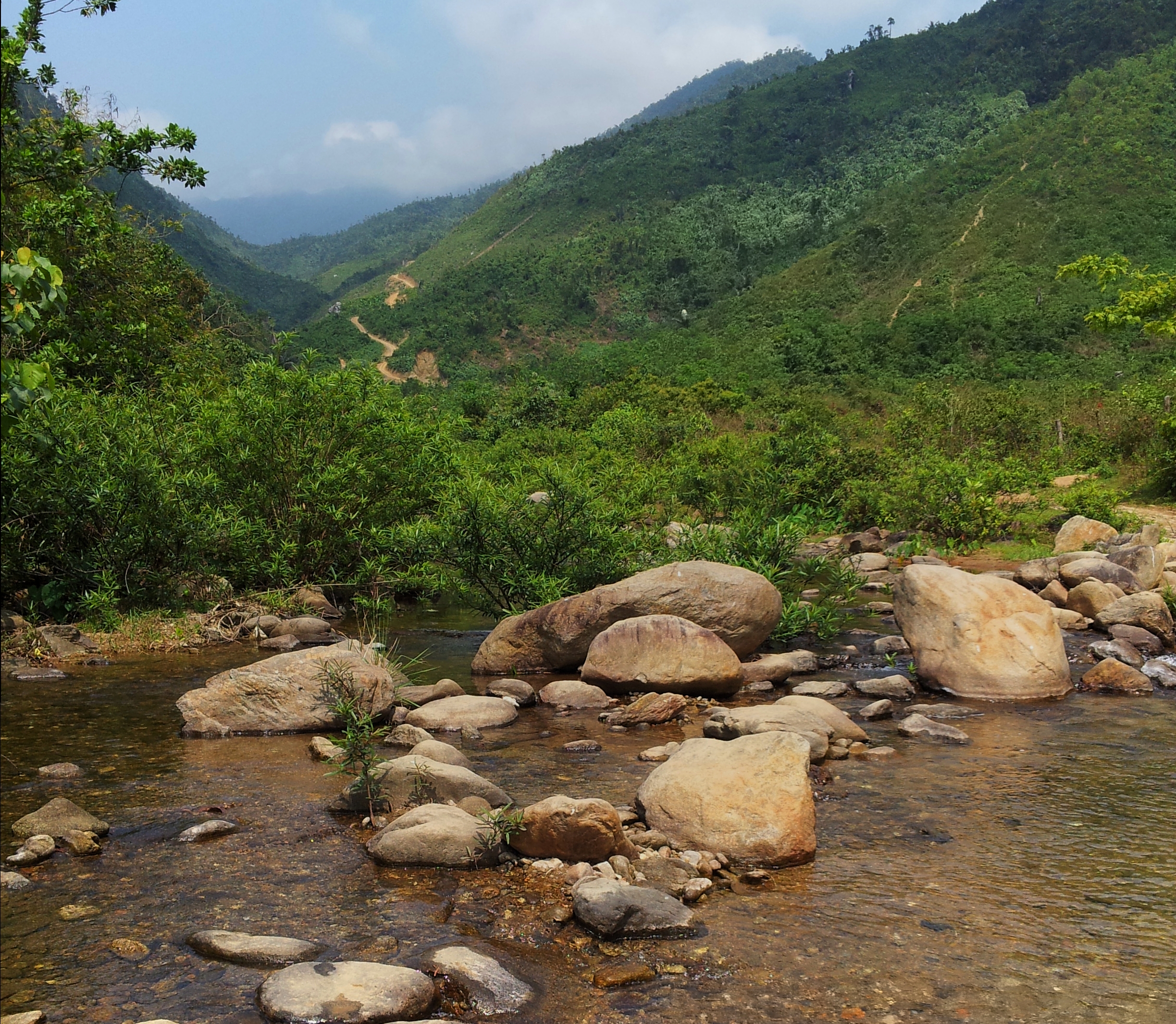
The main road continues up the South Fork for a few more kilometers before the "end" of the road. This stretch is quite beautiful, with the mountains coming in close and framing a river with some decent looking whitewater on it. Finally, this valley looks like a real-life river canyon, rather than a flat-bottom wide valley. However, just as the valley starts to get good, the road comes around a corner and abruptly ends at a gate. This gate is meant to block traffic from proceeding along. It is temporary, as one day the four lane highway between DNG and Hue will be finished, and one can finally go further up the valley. But for now, it's the end of the line, and guy at the house at the end is uninterested in bribes of any kind to look the other way.

|

|
Clockwise from Top Left: Construction office; South Fork Cu De Rapids; South Fork Cu De looking upstream; South Fork Cu De looking downstream.

|

|
North Fork Valley

"Secret Valley".
|
While there isn't a nice road up the North Fork, and while you can't go too far up this fork at the moment, it is possible to drive [or hike] up a sketchy dirt road to access the bottom reaches of the valley of the North Fork until you are stopped by yet another gate. However, you can access a tiny piece of this "Secret Valley" by hiking through a couple fields down to the river. If you make it all the way to the gate, some guys will follow you all the way back to the confluence, so if you don't want to be stopped and escoted, turn off the main road and make your way to the river before you reach it. Be wary of floating back down the river though, there are two stout rapids in the pinch where the river leaves "Secret Valley" and joins the South Fork.

|

Clockwise from above: "Secret Valley"; North Fork Cu De rapid; Gate that blocks traffic.

|

|
North Valley Road
On the other side of the valley from that road there is another, smaller road that also parallels the river. It's not as long as it's southern counterpart, only extending as far as up as the majestic basin at the start of the Lower Valley. However, this road is much more quiet than the other road, and offers a different view of the Cu De Valley, and may just be the real gem of the whole river valley. The road passes through several small villages, crosses several creeks after they exit their steep canyons, and provides a wonderful rural feeling as you drive along.

James Conder driving between the two Valley roads.
This road actually starts along Highway 1A, in Lien Chieu District. To get here go across the Nam O Bridge, and turn left immediately at the first possible intersection. The first bit of this road is through Lien Chieu, and it drives past shops, housing projects, and restaurants. After a couple of corners the city falls behind and you will find yourself driving along the Cu De River. Sharp eyes will spot a small shrine located on an island in the river. Soon the road crosses under the Highway 1A Bypass, where there may or may not be a small coffeeshop. After the Bypass, the road is briefly squeezed between a the river and the hillside, but it soon goes around a corner, passing an area of aquaculture along the river, before turning the corner and entering a small open floodplain around a creek that comes down from the mountains here.


|
|
Clockwise from top: Island with shrine; Lower Cu De Valley; Aquaculture ponds; Traffic jam under the bridge.

|
One of the interesting things about the North Valley Road is the number of small creeks the road crosses as it drives along. These creeks, while slow and meandering as the road crosses them, all contain gradient and waterfalls just a short ways up from the valley bottom; however, accessing these can sometimes be a pain in the butt. The first of these creeks ("Ti Tou Creek") contains a small waterfall just upstream from where the creek flattens out and loses it's gradient. It is a small pool into a clear pool, and is a nice quiet respite from the heat. Recently they built a logging road up this valley past the creek, but the last time I saw it (which was a couple years ago) the pool and falls had escaped ruin up until that point, but this could change at any time, if it hasn't already.
|

"Ti Tou" Creek.
|
Shortly after this creek, the road wraps around another bend, and briefly goes between a small hill and the Cu De River. Wrapping around a small point, the North Valley Road then enters the majestic basin that makes up the upper end of the Lower Valley, crossing two more creeks in quick succession and passing through a small town. The first of these creeks, the Khe Ram, comes out of a steep and narrow gorge and flattening out onto a small river plain. There are usually buffalo to be seen along this creek, and intrepid explorers can hike up the creek to access the river upstream.

Justin, Kathy, and Shann on the bridge over the Khe Ram.
"Buffalo Creek".
|
A short ways beyond this is another creek, this one called "Khe Hoi Yeu", although I prefer to call this one "Buffalo Creek", as there always seems to be a handful of buffalo sitting in the creek underneath the bridge, especially on hot summer days. This creek can be explored a ways upstream by utilizing the old logging road that goes up along its north side. Likewise, there is another tiny creek [whose waterfalls you can see from across the valley] you can hike up so, provided you are ok with a bit of thrashing through the bush. If you do decide to stop in and visit this area, be polite and courteous to any locals you meet. I drove through here just a handful of times over the course of two years but it was enough for several of the locals to remember me.
|

Khe Hoi Yeu side fork.
|

"Buffalo Creek" Valley.
|
Back on the main road, you will very quickly pass by a Catholic church on the north side of the road. This is a good indicator that the turn to access the South Valley Road is near. You can choose to make that turn, which will take you across an epic series of rice paddies (where I have almost always seen blue-throated Kingfishers), before hugging a couple quick corners and coming up to a small and pretty bridge over the Cu De. This bridge has been painted silver and red over the years, but to me it will always be "the Red bridge".

|

|
Clockwise from top left: Catholic church in Nam Yeu; Looking down the Red Bridge; the Red Bridge.

If you don't turn here, it is possible to continue along for a few more kilometers. Ultimately the road ends at an interesting facility where the friendly but firm security guards will insist on you turning around. On Google Earth the road continues around the side of the facility before turning into a dirt road that slowly makes its way up the valley of the Suoi Cay, however the guards will not let you pass. There is a dirt road that turns off the main road just before this facility, although I have yet to drive all the way up this to see where it goes. However, a short ways before this facility, there is a small nondescript valley which holds a small hiking trail that goes a short ways up the creek, or you can climb up a small hillside to a cabin/lookout on a small ridge above the valley. There is a fence you must cross but if you look closely you should be able to find a gate. Once you have finished exploring this section of the road, there is little choice but to head back either the way you came or over the Red Bridge to the South Valley Road.

Lance enjoying the small side fork hike.
And that is most of what the Cu De Valley has to offer. Sure, there are unmarked dirt roads that take off into the mountains that have yet to be explored, but as far as main roads, this is basically most of the key places you can expect to see and visit whilst in the valley.
So what does the future hold for the Cu De Valley? In the near future, some exposure to construction noise and traffic, although this should be contained to the South Valley Road, and more so in the Upper Valley as the new highway stays in the hills for much of the Lower Valley. For the most part, the North Valley Road should be unaffected for the time being. However, once the highway is completed, things will change quite rapidly, especially for the Upper Valley, as the highway will occupy a large portion of the narrow valley bottom. Eventually hotels, restaurants, gas stations, shops, and vehicle repair garages will pop up throughout the valley. New areas of development and houses will be created. Roads leading off into the jungle will be cut. The change will be even more noticeable beyond the current gate along the South Valley Road; beyond this there has been almost zero development so far, and once a four lane highway exists the development will only be a matter of time in coming.
The one saving grace for the valley is that while development will come fast and heavy to the South Valley Road, hopefully the North Valley Road should be able to escape some of that and retain it's rural nature. Of course, nothing is ever going to last in Vietnam, considering the breakneck pace of development and modernization that is happening right now. So, I guess the message is to get out and see it now, while you still can, because ultimately this valley, especially it's upper reaches, is poised for big changes in the near future. You wont regret a day trip to this amazing place. Thanks for reading and enjoy!

Bridge and road cut, signs of the impending changes that the Cu De Valley is headed towards.
The Map
All photos copyright Kit Davidson.
Maps created with a copyright Google MyMaps.
Maps created with a copyright Google MyMaps.
