
Luong Dong River

At the put in for the Class IV section.
Upper Section - "Rowdy Section"
|
Middle Section - "Class IV Section"
|
Lower Section - "Foothills Section"
|
|
Section Length: ~3-4 km
Put In: Logging road above Suoi Hoa Take Out: Trail to road (see text) Difficulty: III+ - V+ (P) Est. Flow: too low < 100 < 500? < too high Paddlers: Not Finished Yet Character: Bedrock, granite boulder gardens |
,Section Length: ~3 km
Put In: Corner below Ngam Doi Rapids Take Out: Phu Tuc town Difficulty: IV Est. Flow: too low < 200 < 2000? < too high Paddlers: Kit Davidson, Alfonso Perez, Ian Belknap Character: Granite boulder gardens |
Section Length: ~6 km
Put In: below Phu Tuc rapid Take Out: Hoa Phu or Dieu Phong Difficulty: II+ Est. Flow: too low < 200 < 5000? < too high Paddlers: Kit Davidson, Alfonso Perez, Ian Belknap Character: Gravel bars & riffles |
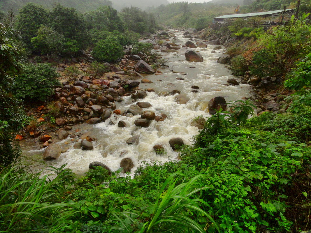
The Luong Dong is a smaller river not far from the city. Representing one of the closest legit paddle options to the city, the runnable window on this stream is unfortunately short, often only flowing for a couple months out of the year. However, when it has water, the short river has three distinct sections on it for paddlers of all levels, including the rowdy upper section, which has some impressively huge boulder gardens cascades; the class IV "middle section", which is very reminiscent of USA's famous Arkansas River and a lot of fun; and the milder class II foothills run at the bottom. Located only 30 km from Da Nang city, this stream can be reached in less than an hour from the city, providing a quick relief for boaters in need.
Upper Run - "The Rowdy Section"

The first of the crazy gorges.
|

The better looking section of the upper gorge.
|
|
The Luong Dong is actually runnable as far up as Hoa Phu Thanh, thanks in part to that company altering the river bed to allow boats to get down it. However, they control access to the upper most reaches of this creek so if you want to paddle this short gorge, you must ask permission first. The run itself is novelty boating, with several hairy drops that border on the skate park drop variety. They send unknowing Vietnamese tourists down in small little two-person rafts with no paddles, so it can't be that bad, right? Boat at your own risk.
Below this, you can actually put on at a logging road located between the lower Hoa Phu Thanh Village and Suoi Hoa. This gets you a very short corner with one bedrock drop that may or may not be runnable based on the water level, but it should be portageable and all but the highest of flows. After a short spell, there is a short class III rapid around some big boulders, before one more short break. After this the river drops through an impressive staircase of massive boulders that may be runnable but is packed with sieves. Below this is a short flat stretch, and below is an ever larger section of boulder cascades, but this one is a touch steeper so it doesn't really go. A brief mellowing of the gradient offers a very short section of pool drop rapids that are one on top of another, but they may go with some heavy scouting. |

Good lines, and sieves too...
|
Anyone attempting this short section should be aware that the last rapid, set in the last bend before the Ngam Doi Flats, is a junky rapid that is UNRUNNABLE and must be portaged. This ugly jumble of rocks (pictured above) is full of boulders and does not have any clean lines. Best

Above & Below: The very short section at the end of the super steep section. Be aware of a PORTAGE directly below here!!


Looking down into El Rapido Espanol Primero....
|

...and back up at the same drop.
|
Although it feels like the Ngam Doi Bridge should be a natural split between river sections, the rapid immediately downstream from the bridge (El Rapido Espanol Primero, or First Spanish Rapid) is more on par with the section above than below, so it should be considered the "end " of the Upper section. This rapid actually looks inviting- a huge boulder bar parked in front of a bedrock wall, with a nice liking line down the left. However, there is a nasty sieve on the right side of the channel about halfway down and in front of a backed-up hole, so although the line may be straight forward the consequences are high. That being said, this drop has been run successfully with a report of "easier than it looks".
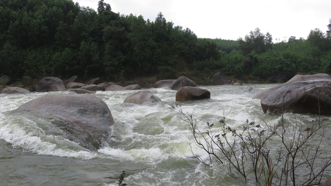
Middle Run - "The Class IV Section"

Alfonso Perez in El Rapido Espanol Segundo.
After El Rapido Espanol Primero, the technical rapids start right away. The first drop is a short abrupt mess of boulders that is do-able but is very junky with no clean lines. Just downstream is El Rapido Espanol Segundo, which is a short but steeper rapid in and around some boulders in the middle of the river. There is an interesting move at lower levels into the backwash below one of this boulders that is softer and more fun than it looks. Just after this is a series of easy class II/III drops, beginning with Ian's Pocket, a small and surprisingly sticky chute through some boulders. Below this is Chunkey Monkey, which is a boulder garden that is surprisingly steep. There are small boulders lurking in this staircase so be ready with a Plan B or C.

Chunkey Monkey Rapid.
|

The easy stuff above Phu Tuc Rapid.
|
A brief calm gives way to Bumpin' & Grindin', which goes well down the left channel for a long ways, but then ends in awkward staircase that may or may not have enough flow to get down. Once the channels come back together, the river goes around a corner and drops through some fun, easy class II rapids down and around the next corner. Below this the river turns back left, and then accelerates down through a ramp of small holes and drops into Phu Tuc Rapid, which is pretty solid and beastly at high flows and steep and technical and lower flows. There is a decent line entering left and working towards center at high flows, but at low flows the whole mess becomes an unclean and awkward mess of boulders and channels. Below this the rapids pretty much end quickly and the river transitions into a much more flat riverbed.
|

Phu Tuc at medium-low levels.
|
Lower Run - "The Foothills Section"

Foothills run with Nui Chua (Ba Na Hills) rising behind.
The lowest run of the Luong Dong River is a fun stretch of class II+ through a bunch of corners and straightaways down to Hoa Phu town. The biggest issues on this stretch are not any rapids (although there are a couple, including one fairly quick after Phu Tuc town [Surprise Rapid], and another one near the Work Release Camp [The Plastic Forest]) but rather from combinations of gravel bars and drowned willows. As this river only runs perhaps two or three months a year, its common for willows to choke out the river bed during the dry season. When the river then fills with water these willows can sometimes provide exciting tunnels and hallways to cruise through. But other than this the river down to Hoa Phu is basically flat. One neat thing about this stretch however, is that it gets away from the road, and for the most part, people, for a short stretch below The Plastic Forest. It is very quiet and there are lots of birds. This continues down almost all the way to Hoa Phu. You can continue down to Dieu Phong and the confluence with the Tuy Loan River, or even down to Tuy Loan town, but it only gets more flat and more slow the further you go below Hoa Phu. Pay attention towards the bottom and you might spot the hidden mini-waterfall on the left river bank!

End of the rapids.
|

Mini-waterfall hidden in the Lower Section.
|
Access Logistics
The whole river is roadside, and that means lots of accesses from top to bottom. Some of them are unmarked and require paying attention, and at other times you might have to stroll through the woods for a second or two, but with the exception of the lower part of the upper gorges, everything is basically easy to get to. Starting at the bottom, the best access in Hoa Phu town is to cross to the north side of the river, and turn onto the road just past the bridge; just down this road turn right and there are several small paths that head to the river. Heading up, there is decent access at Phu Tuc town (a small road down to the river), as well as just before Ngam Doi Resort. Between the entrance to Ngam Doi Resort and Ngam Doi Bridge is a decent access by hiking through the trees. Above this the next access isn't until the flats between the two gorges in the upper section, which is accessible only by a steep trail. There is a similar trail just above the first of these gorges, and another again just above the first big boulder class III. Above here the only real access is via a small logging road between Suoi Hoa and Hoa Phu Thanh.
|
All photos and videos copyright Kit Davidson.
All maps copyright Google MyMaps. All music copyright original owners and is not to be used for profit. |
