
Song Thanh - "Roadside" Section
|
Section Length: ~ 5 km
Put In: below Pa Xua Take Out: Confluence w/ Dak Mi River |
Difficulty: Class II (III-)
Est. Flow: too low < 400 cfs < too big < 20,000 (?) Paddlers (on this page): Cuong Phu Huu Tran, Kit Davidson, Le Hoang Minh, Tran Nhan, Michael Morlok, Alfonso Perez |

Cuong Tran in Torrezno Rapid, with the bridge to Nam Giang in the background.
The Song Thanh is the best bread and butter year-round fix for Da Nang boaters. It is the closest run that has flow nearly the entire year, and generally offers fun rapids and a worthwhile day of boating no matter how high or low it is. Although short, this can be combined with a run on the Lower Song Giang section immediately upstream- creating a beautiful 10 km section of river- or with parts of Ca Dy Canyon on the Dak Mi River, which is in the canyon next door. With easy logistics, several access points, and a forgiving nature, this stream is destined to become more popular as boating develops in the Quang Nam area, and with good reason. It really is a fine river and makes a fine day of boating.

Le Hoang Minh loading up.
|
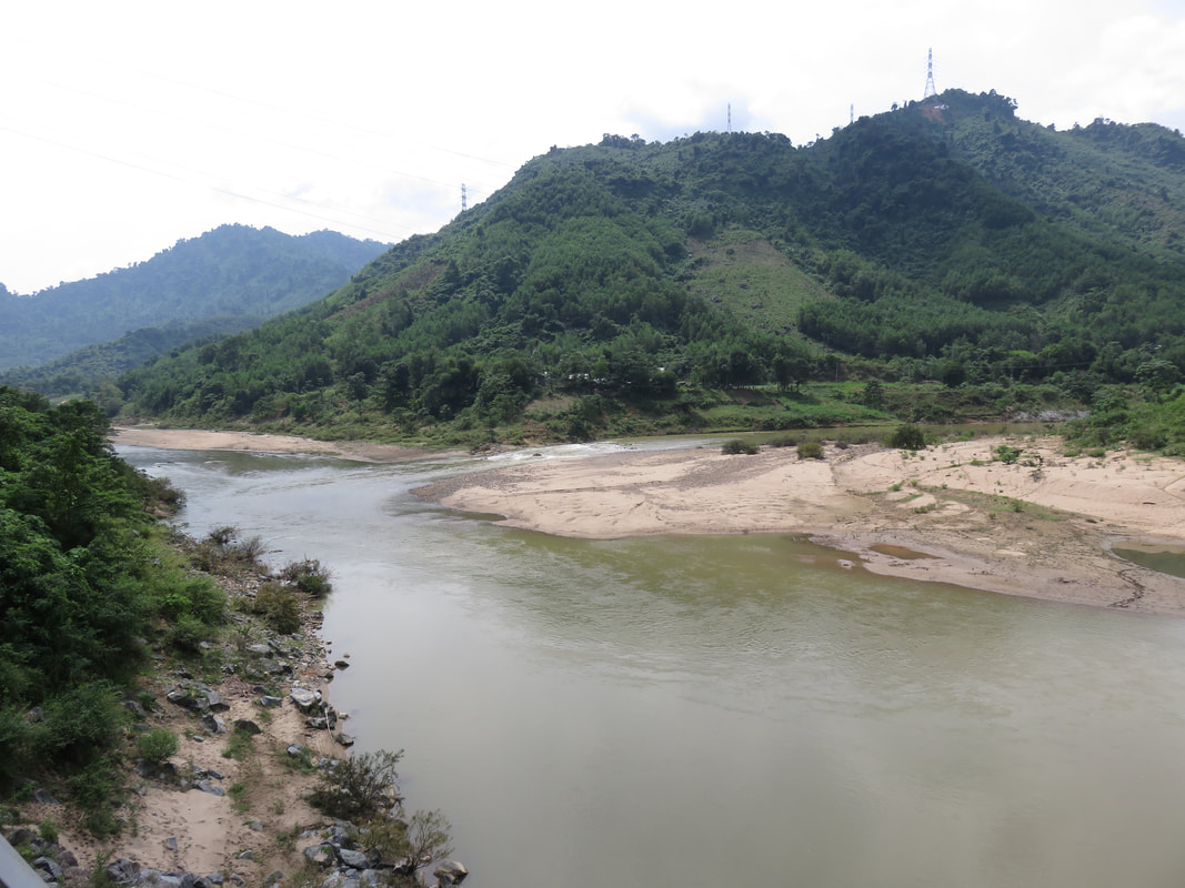
Confluence of Dak Mi (L) and Thanh (R) Rivers.
|
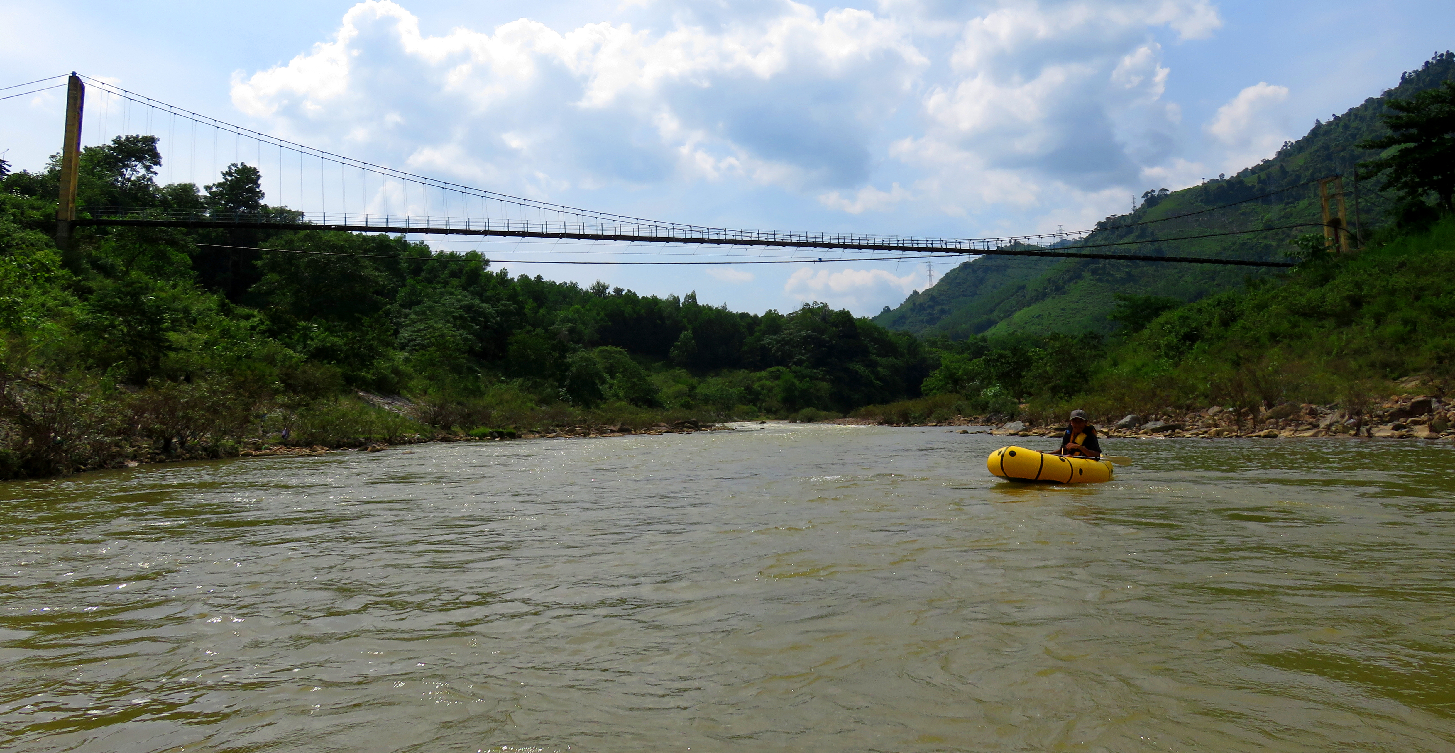
The logistics are pretty straightforward. This section of river is parallel to the road for it's entire length, and the put in is where the river exits its last roadless canyon and joins up with the road. It can be a little confusing to find the put in, but you are looking for an old road, with a couple of graves nearby, and a simple bamboo gate across it. It is immediately downstream of a large government suspension bridge. I don't know much else to say other than trust the Google Maps pin at the bottom of this page. The takeout is really easy- it's located in Ben Giang, and a short flight of stairs connects the river to the takeout beach. There are a couple of other accesses throughout, including at all the suspension bridges you pass, as well as between the Mini Gorge and Turtle Rapid, and again just above Swiss Cheese rapid.

Put-in scenery.
|

Just after putting on.
|
The put in is in the middle of a lengthy flat section, just after the river breaks out of it's last canyon and enters the wider Pa Xua Valley, and underneath one of the several government-built suspension bridges that cross over this section. This is nice because it allows time to get comfortable on the water and take some practice strokes. A fair ways downstream you can see a small narrowing of the river, but in between the put-in and that it's mostly flat, moving water, broken by a few small riffles that are perfect for some practice strokes.

Cuong coming through the first part of 1st Rapids.

Cuong in 1st Rapids.
The first real rapids, named "1st Rapids", come as the river makes a jog to the right and then back left while dropping over a gravel bar and some large boulders. These are small and fun. There are two parts to this rapid, a series of fun riffles set on a bend to the left, and then a short ways down a choice of small holes to splash through. It's all easy and fun. Below this is another government bridge, which may have some friendly Co Tu locals waving at you from it.
|

Blasting through the lower holes of 1st Rapid.
|
One of the government-built bridges.
|

Typical scenery on the Song Thanh.
|
After a short flat and straight section, the river soon makes its way to the base of a small but sharply defined hill on river left. The large guol in Ben Giang is on the other side of this, which serves as an access point if need be, and it also signifies the approach of two features.
The first feature is not really a rapid, more of an interesting novelty of the river. Here, the waters have carved into a beautiful mini-gorge on river left and center. There is no real gradient loss and thus no "rapid", but it is cool to float through. Paddle probing will reveal impressive depth, and it's likely this pool would make for a good cliff jumping spot.
The first feature is not really a rapid, more of an interesting novelty of the river. Here, the waters have carved into a beautiful mini-gorge on river left and center. There is no real gradient loss and thus no "rapid", but it is cool to float through. Paddle probing will reveal impressive depth, and it's likely this pool would make for a good cliff jumping spot.

"The Mini Gorge" section.
|
Beautiful scenery abounds.
|

Michael Morlok coming through Hidden Rapid.
|
Just downstream and around the bend is the second feature, which is a real rapid, called "Hidden Rapid", and much like 1st Rapids, this is a choice of a fun hole to splash through. The best line is to the right of the small bedrock island. Left is ok but less of a drop. Below this is another suspension bridge, and this suspension bridge reveals the ultimate conundrum with these bridges- they would make fantastic platforms to shoot pictures from, but actually reaching them from river level is not as easy as it looks. The above picture was taken from a rock outcropping a short ways underneath the bridge, giving an indication of just how high up those bridges are.
Almost immediately below this bridge on the right is a very interesting feature that is worth stopping and investigating. Here a small side stream has carved an interesting little mini boxed in canyon just before it's confluence with the Song Thanh. This low flow stream is well worth a stop to explore and look at. 
|

|

Michael running Swiss Cheese Rapid.
At the end of the short lake-like flat section, the river makes an almost 180-degree bend around a small hill, and then abruptly falls through a somewhat junky rapid called "Swiss Cheese Rapid". The shape of this rapid has fluctuated over the years as the floods seem to re-arrange it every year, but generally there are two lines: a far left line, (called "Butt Breaker") which is shallow but usually has far less water (and thus less power), but has a junky exit, and a center line, which is surprisingly manky, even at higher flows, but is typically good to go. Sometimes a far right line along the bottom of the hill opens up, but its also often times too junky to run. This rapid is essentially a giant gravel bar, so if in doubt, pull over and have a look. As well as the main drop, there is a decent hole lurking in the runout, and some low-hanging branches could be in play for someone who has drifted too far to the right.
|
|
|

Faraway view of Turtle Rapid.
|

Swiss Cheese, it has changed several times since this photo.
|
Below Swiss Cheese, the river bends begins a series of large "switchbacks", where it loops back on itself a couple of times until it's confluence with the Dak Mi River shortly downstream. Just around a corner is a rapid called "Turtle Rapid", which looks benign from above, but for a small, unexpected rapid it is surprisingly zesty. In addition to pouring over some boulders here and there, the rapid itself actually drops around a meter or two in vertical, and you will get a surprising amount of speed dropping into it. While exciting, its not that difficult, and a strong forward paddle and brace will see you through. The biggest danger may be to stay off the river right wall in the outflow of this rapid.
|
|

Lower A Roang Rapid.
|
Under yet another bridge, and then around the corner and the final series of rapids, the "A Roong Rapids", start right away. The first drop is fun, usually a straight shot down through some splashy but exciting waves. It tends to change a little bit every year like Swiss Cheese Rapid, but it usually seems to be a "straight down the middle" line every year. Like Turtle Rapid, it can be more exciting and fast than it first appears. Just around the bend is the middle drop of the series, which is nothing more than an easy riffle with some small holes to avoid.

|

|

|
Left to Right: Sequence of Cuong running Torrezno Rapid.
The final rapid is a lot of fun and a great way to finish off this run. Here the river falls over a couple of small bedrock ledges, creating a series of holes and waves that are surprisingly powerful. The upper level is pretty simple, just a plop and drop through a small hole, but the lower part has more punch than you'd think. You'll need some speed to punch this drop, and it is notorious for dishing out swims to those who aren't ready. An easier line on the right and far left offer sneak routes, but really, why would you want to? For playboaters, this wave has some ok play, serving up some mild tricks, and while it isn't anything special or rock star, it is fun to end the trip with a short play session.
|
|
|
This river can be run almost any month of the year, although it is possible to find it too low if it has been months without rainfall. We have run this in July with around 500 cfs in it, but I don't know if it would go much later. I have seen it in April and thought it would be a long day of dragging and not much fun. On the other end of things, beware between October and January, as that is flood season, and if a tropical system has rolled through, or the monsoon flow is strong enough, it can get quite large too. The run is still quite friendly up to most flows, although Swiss Cheese may want to be walked by some.

Minh and Tran Nhan celebrate a fun run!
|

Alfonso Perez getting some play in Torrezno Wave.
|

Michael Morlok about to join the Song Thanh Swim Team.
The Video
The Map
|
All photos and videos copyright Kit Davidson.
All maps copyright Google MyMaps. All music copyright original owners and is not to be used for profit. |
