
The Dam Problem
How the hydro dams, water cuts, power cuts, beach erosion, islet formation, ethnic people displacement, riverine ecosystem destruction and illegal sand mining are all connected.
There’s been a lot of talk over the past couple of years about a lot of the above topics, much of it mis-informed. So, rather than addressing each one of those topics with the same answer over and over, I thought I would put together a bit of info to put an end to the discussion and questions once and for all. In this, I am going to lay out and show how many of the things that are talked about in this group- the hydro-electric dams, the ongoing water cuts & water quality issues, the power cuts, the beach erosion & the associated destruction it brings and more- are actually connected in a giant web where actions on one end can cause major repercussions on the other. There has been quite a bit of mis-leading or even outright false info being thrown around (rather confidently by some folks), so it’s time to lay it all straight so there is no more confusion. I have provided a fairly in-depth analysis about the whole process in a step-by-step layout, but I’ve also provided a TL;DR at the end of each section for helpful relevance.
***
Before we get into the problems, we first must understand beach formation. Beaches, as you are aware, are made of sand and sediments. But where does this sand and sediment come from? “Duh, the ocean!”, you might find yourself saying. And while some sediment is ocean-borne, much of our sand and sediment on beaches comes from a process called “longshore drift”, where beaches form as a result of river sediments being washed into the sea, and those sediments then being carried by local tides and swells to form beaches along a stretch of coast. This is how the magnificent beach that stretches from Son Tra all the way to Nui Thanh was formed. Over millions of years the Vu Gia River system, which drains a massive area of northern and western Quang Nam, has brought down untold sediments out of Vietnam’s mountains. In turn, this sediment gets dumped into the sea via the Thu Bon River delta (before humans the Vu Gia used to empty out at Hoi An, not at Da Nang). Thanks to the location of the Cham Islands and their surrounding bathymetry [underwater landscape shape], which acts like a barrier, those sediments get turned around and thanks to the swell and tides, gets deposited onto our beaches. Local currents also carry sand up and down the beaches as well in either direction.
TL;DR, our beaches come from rivers, esp. the Vu Gia and Thu Bon Rivers.

Diagram of typical river-borne sediment transport and longshore drift & deposition.
***
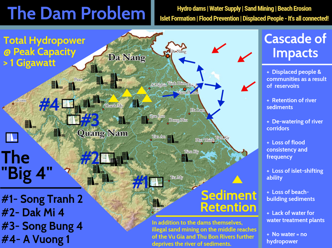
Now that we know how the beaches are formed, let’s get into the next step: the dams. As you all know, Vietnam is blessed with lots of mountainous terrain and ample rainfall. The result is a network of countless rivers and streams, some of which become quite large in a short distance. Because Vietnam was so under-developed after the US War (with populations of people being pulled out of remote mountain villages and centralized into new towns], these mountainous rivers represented a perfect opportunity for Vietnam to utilize in the form of hydro-electric power. So, countless plans were drawn up, and over the past 30 years, numerous dams and reservoirs have been created to tap into this (mostly) clean and (mostly) renewable energy source. The numbers are staggering; in Quang Nam alone there are over two dozen dams used for hydro-electric power production. Many of these dams are built in the typical “run of the river” style, where a reservoir is created to pool up water. This reservoir is then drained by a long pipe (called a “penstock”) around the lake (usually under a mountain or through a hillside) and to a power plant located some meters “downhill”. The falling water then spins turbines inside, generating electricity, and then the water is returned to the riverbed. This is by far the most common setup in Quang Nam’s hydropower scheme, and the “Big 4” Hydro Dams in Quang Nam (A Vuong 1, Song Bung 4, Dak Mi 4 & Song Tranh 2) are all of this design. As a result, almost all of the power in our area, and a substantial amount in the rest of the country, comes from hydropower. In fact, if every hydro power plant in Quang Nam alone was running at peak levels, the combined electrical output would be over 1 Gigawatt! So needless to say these dams are very important to us and our electricity-driven world.
TL;DR, post-war Vietnam built many hydro dams because they were cheap and relatively “clean”, we now get lots of power from hydro.
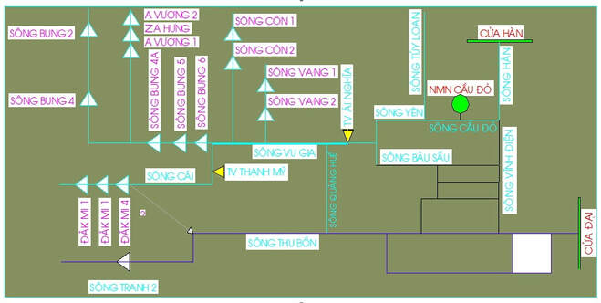
Network of hydropower dams in Quang Nam. This isn't even all of them!
***
Now we understand beach formation, and we understand where the dams came from. Which means its time to get into the gritty side: the problems these dams have created. Let’s take a section-by-section look from top to bottom of just what has become affected because of these dams:
1. Displaced Peoples & Loss of Land
Some of the reservoirs in Quang Nam are quite large, and their construction has meant the flooding over numerous villages and communities, along with the fertile river-bottom lands they were typically built on. These valley bottoms were extremely productive because of the consistent floods that would sweep down these rivers in times before dams. Each flood meant more nutrients into the soil. Losing this fertile and arable land, and losing their traditional villages, has meant the end for some of these communities. Because these reservoirs are in the mountains, more often than not the communities that were flooded out were of ethnic groups, such as the Co Tu in Quang Nam. These displaced peoples have lost their homes, their lands, their communities, their sense of identity, and have been forced to live elsewhere, often in areas not suitable for cultivation or often lacking access to good water.
2. Riverine Ecosystem Destruction
In addition to the human cost, each dam destroys two sections of riverine ecosystems in two different ways. The first is upstream of the dam, where the aforementioned river valleys and river bottoms- as well as any canyons or gorges- are flooded out and replaced with a large reservoir. The second is downstream from the dam; ‘run of the river” hydro schemes often build dams at the beginning of narrow gorges or canyons, as it usually represents the chance to build a small dam with a much larger reservoir, as well as benefit from the drop in elevation that gorges and canyons usually have. In many situations, the power plant itself is located quite a few kilometers downstream from the dam, resulting in the de-watering of a lengthy corridor of river, which can be incredibly harmful to the animals within this riverine corridor, the animals that live outside of but still rely on the river, as well as the riverside vegetation.
3. Loss of Consistent Floods
But wait, you say, didn’t we have flooding just a few months ago?? Well yes, we did. And we still seem to get a decent flood once every couple of years. However, this is not talking about those massive events that happen once a year or less, but instead the smaller, more consistent floods that would typically happen several times a year or more. Before the era of dams, it was possible to receive multiple smaller floods from time to time thanks to flooding happening in different rivers. It wouldn’t matter if the flood started in Dong Giang or Nong Son or Bac Tra My, wherever it started, it would bring waters down the rest of the system below it. But, by building dams not only on a single river, but often multiple tributaries throughout the drainage basin, it removed the river systems’ ability to provide any floods, except for the massive floods like in November 2017. But what does that matter, you ask? Isn’t controlling floods a good thing? Well, not so much, and that’s because of the next one…..
4. Loss of River Sediments
This is the big one, and it’s a two-fold punch. First, we are losing the sediments because of the dams themselves. Dams can remove up to 98% of a river’s sediment load, and that is just one dam. Imagine a river like the Song Bung, which has no less than 6 dams currently blocking it. These sediments, as we learned in the intro about beach formation, are CRITICAL to re-supplying the area’s beaches with sediments. Second, the sediments also help mitigate flood damage by creating sandbars and sandbanks in and along the river. Removing the sediment, or not letting the sediment move around with each flood, encourages the river to channelize, which leads to increased erosion along the banks, and results in more damage when a flood comes. As well, the sediments in the shallows of rivers are often rife with all manner of riverine creatures, including fish, crustaceans and amphibians. So, by adding dams to a river, not only we are preventing the crucial sediments from coming downstream, but we are also removing the river’s power to move around what other sediments remain in the system from non-dammed tributaries, leading to the increased flood damage on river sides. These days, by the time the river manages to reach sea, it has a tiny fraction of sediment load that it historically carried.
5. Hoarding of Water in Reservoirs and Power & Water Cuts
Because so much of our local power grid is dependent on these hydro dams, and because our rainfall is often feast or famine, it is imperative for these dams to hoard water in times of no rain. Doing so allows for continued generation of power, but that comes at a cost: the rationing of that power, and lower levels of water in the rivers. When the entire basin is dry, this can lead to multiple dams being offline for multiple hours at a time, which can lead to power cuts in the city. If there is no water in the dams, there is no water for power generation, which means no power. As well, because there isn’t much water being released out of the dams in these times, there is no water for the water treatment plants around the city. This leads to water cuts, like the ones experienced in Fall 2018. This problem can also become extremely problematic as many of the area dams have a “dead pool” level, which means if it gets low enough, the dam CAN’T release any water, whether for power generation or water release.
TL;DR, dams destroy ecosystems, force people to move, stop productive small floods, remove sediments from river, and can lead directly to power cuts and water cuts
***
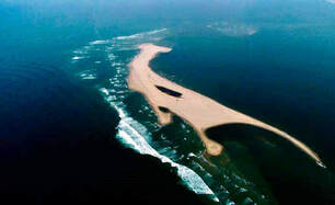
We are getting there, so stay with me. Now that we understand rivers & beach formation, as well as why the dams are there and are so bad on the upstream reaches, we need to look at the downstream reaches and whats happening. The first thing to note is the formation of a small islet directly at the mouth of Cua Dai port. This islet is formed from what little sediments have managed to make it down through floods or from undammed tributaries. The river, because it has been deprived of its consistent floods, doesn’t have the ability to move these sediments, and slowly but surely an island is taking shape. (Picture ->) But the second and far more critical piece is the beaches. Because there has been so much “weight” added to the area beaches in the form of development of resorts and hotels, the water within the porous sandy ground underneath them has been squeezed out, and erosion of the beaches are occurring at a deeper level. This in itself would be a worrying issue, but the real problem here is that any replacement sediments that would normally be filling in those carried away by the tides are gone because of the dams. This results in ongoing beach removal and destruction.
TL;DR, sand goes out, sand doesn’t come back in, sand keeps going out, beach erosion gets bad
***
And finally, its not a huge piece of the puzzle, but it is worth mentioning because it exacerbates the problem: illegal sand mining. This activity happens along the middle reaches of the larger rivers like the Thu Bon, Vu Gia, Cai, Dak Mi and Tranh, and removing even more sediments from these sandbanks prevents them from ultimately making it to the sea, and thus back to the beaches. So not only do the dams stop massive amounts of sediments from flowing downstream, but that mining removes even more of what little bit is left. A problem on top of a problem.
***
I thought about citing my sources for this but they are too numerous to mention so you’ll just have to trust me. I come from a familial background of geology and hydrology, and as a river kayaker I am intimately aware of riverine ecosystems and the influence dams have of them. I have spent a good portion of my adult life actively learning about these topics as a hobby, including essays and analyses on displaced peoples as a result of these hydro projects. But, it’s not just my words, even the Vietnamese authorities are citing the dams as the main overall culprit for the beach erosion, so you don’t have to believe just me. If you have further questions please don’t hesitate to ask.
