

Top 15 Beautiful Vistas Around Da Nang & Quang Nam
Thanks to Da Nang's mountainous environment, there are countless incredible views to be had around the area. Many of these are quite popular, such as the famous Rock Viewpoint on Hai Van Pass, the view of Da Nang from Dinh Ban Co, or perhaps the vista of Son Tra from An Bang Beach. However, once you get past the heavily visited viewpoints you can find some amazing gems out there, especially in neighboring Quang Nam Province. Here is a list of 15 incredible viewpoints that are well worth taking the time to visit.
The Honorable Mentions
These five are some amazing viewpoints in their own right, but they just miss the list because of being on well-traveled routes, or having a negative feature that takes some points away. These are still great points and are just as can't-miss as the ones that made the cut.
HM #5 - A Zich Village - Ho Chi Minh Road - Tay Giang

Found on the Ho Chi Minh Road between P'Rao and A Luoi, this view is just before the town of B'Ha'Le'e, about 15 kilometers west of P'Rao. The highway rises up and over a small pass, and abruptly around a corner just beyond this divide is this incredible view of a Co Tu village down in the valley bottom. The building in the center is called a "guol", and is the central community house for this village. The hills in the background are classic central Vietnam rolling green mountains and further help enhance this view.
HM #4 - Nui Chua Summit - Ba Na Hills

This one misses the cut because the opposite side of this view is of the monstrosity that is the Ba Na Hills development. However, if you turn around from that, you get this surprisingly peaceful view of the summit of Nui Chua- Temple Peak- which is the actual mountain Ba Na Hills is built upon. These temples long proceeded the carnival like amusement park and village that exists now, and while most days the view is obscured by clouds, on rare clear days it is possible to look down on the surrounding area. When the clouds are present, it can feel like you are standing on the edge of the world. Either way, it is a nice peaceful yin to what is the crazy yang of Ba Na Hills.
HM #3 - Nui Chua & Teafields - Xa Ba - Dong Giang

On clear days, you can actually look down from the previous vista down to this one. The Teafields of Xa Ba are a small region of numerous plantations just south of the Nui Chua massif, just inside Quang Nam province. The area is blessed with plentiful rain, thanks to the presence of the mountain to the north, and the whole area is very lush and beautiful. On clear days, the peak of Nui Chua dominates the view, and you can make out some of the structures on top, while on cloudy or hazy days the mountain can be difficult to even see. But, most of the time, this is a great view of some beautiful tea plantations with a large mountain behind it, covered in jungle. It's so good that wedding companies in Da Nang are willing to drive out here to shoot wedding photos with this view.
HM #2 Ma Cooih Overlook - HCMR South - Dong Giang

Another one that just misses out on the cut because it's on the Ho Chi Minh Road, this one being on the section between P'Rao and Thanh My. This view is especially neat if you have some context to go with it- the small limestone hills in the foreground and middle ground and from a very strange and isolated piece of limestone that exists here as a tiny island surrounded by other rock types. The larger mountains behind are granites, and the rocks under this vista spot are sedimentary. So you're actually looking at THREE different kinds of geology in one frame. Pretty neat! Plus, the rolling green mountains help take your eyes away into the horizon as well.
HM #1 - Huu Trach Gorge Overlook - HCMR North - A Luoi

This photo was the hardest one to bump, and in reality should be up much higher on the list. Because while it is on the Ho Chi Minh Road, about 40 km beyond HM#5, it does happen to be found along one of it's most remote segments. But, part of the criteria for this was "Remoteness" and let's be honest, the Ho Chi Minh Road is fairly well traveled these days. This view is just one of several incredible ones found along this stretch of the HCMR as it wraps its way around and into the headwaters of the Huu Trach River. This gorge is truly a remaining "wild space" and is some of the last haunts of the sao la, a species similar to deer and muntjacs. Enjoy this view simply for the immensity of the place!
#10 - A Rooih Valley - Dong Giang

A Rooih is a tiny valley south of P'Rao. It is home to a handful of Co Tu villages, which get progressively younger as you move up the valley. This valley is remarkable because many of the local ethnic people here still retain a lot of their cultural practices, which are falling out in some of the more "modernized" villages along highways. It is quite common to see girls and women in the classic Co Tu woven sashes, dresses, and robes, and often sporting their beautiful blankets. The wild jungle is just above on the hillsides, and rice fields are being terraced in any available space. This is a true piece of authentic rural Vietnam that is well worth a visit and a view. It doesn't hurt that Bol Kin, and impressive mountain range, sits directly above the town itself, too.
#9 - Que Son Peaks - Duy Son Road - Duy Xuyen

If you get visions of Jurassic Park, you aren't alone- this range of mountains is strikingly beautiful and does look like something out of a movie set. These peaks are part of the Que Son Mountains, which are southwest of Hoi An. It takes about an hour to reach these from Da Nang, and about 40 minutes from Hoi An, but that time will be worth it when you see how beautiful this valley is. The best time to visit is between August and January, when the lakes that fill parts of the valley have water in them, which provides even more levels of impressiveness to the view. If you can visit these peaks after rains, expect to see countless small waterfalls coming down the cracks of the peaks as well.
#8 - Ka Dau & The Sentinel - Ma Cooih Road - Dong Giang

Deep in Quang Nam's Dong Giang Province, a handful of Co Tu villages are strung out along an endearing road that cuts deep into the jungle mountains west of the city. One of these villages, Ka Dau, is situated on a small hillside, directly under a large peak that commands the area around it, and stands stubbornly and resolutely higher than anything else for a ways. This village, for better or worse, is tied directly to this peak. And while in the wet months that may prove costly, thanks to the mountain's attraction of tropical rains, it is likely also a blessing, bringing shade and rain even in normally drier months, thanks to orographic lift. So the mountain is kind of a protector to the village, and in the right shot, is an incredible view.
#7 - Nui Mo'Ra - Ghost Valley Road - Nong Son

This view is so unknown to most of the Da Nang / Hoi An area, which is a shame, and that makes it difficult to share. However, it is too good to not pass along, and it would be a disservice to deny this to other explorers. Found down in the wild highlands between Thanh My and Nong Son, this area of lava plateaus and limestone is home to several sets of sharply defined, "teeth"-like mountains. One of the more famous of these is the Bang Am Mountain, which has several impressive teeth-like peaks and rises above the district of Dai Loc; but this range, the Nui Mo'Ra, sits just a handful of kilometers southeast of Bang Am and it's jagged profile and sharply defined limestone peaks are basically unknown. The best time to see this is between September and May, as winds from the northeast will create incredible clouds coming off the peaks and make them even more photogenic.
#6 - Zo Re Valley - QL-14D - Nam Giang

A classic viewpoint because it captures the very essence of modern, rural mountainous Vietnam. From here you can see so many representations of common themes from throughout the country, starting with the continuing march of green and blue mountains, stretching all the way to the horizon. Add a random patchwork of vegetation in wildly different states- old growth, recently cut, 2nd growth, cropland, etc- over that, throw in an ethnic village at the bottom of the valley, and string some power lines coming from what is likely (yes) a hydroelectric dam, and you've got a great view of so many things that you see in Vietnam's mountains. This viewpoint is found on Highway 14-D just before it crosses Deo Ta Po'o and enters into the wild lands of Nam Giang, and its hard not to stop here and just take a minute to enjoy it.
#5 - "Vista Point" - Khe Dienne Road - Nong Son

Who would've thought a small, out-of-the-way dirt road up a nondescript hill would yield one of the better views in central Quang Nam? Yet, that is exactly the case with this viewpoint. Found on a minor hill in rural Nong Son district, the views from this ridge are quite astoundingly amazing. To the south (pictured above) lie the mountains of Nong Son and Hiep Duc, mountains that hold limited ethnic villages, as well as the areas' only remaining population of wild elephants. Beyond this like the peaks of the Xuan Mai Range and, on clear days, the heights of Ngoc Linh, the tallest mountain in southern Vietnam. But that's not all, the view to the east here is incredible as well, looking over the valley of Khe Le and the dramatic peaks of the Que Son Mountains. Two incredible viewpoints for the price of one.
#4 Dac Ooc & Nui La Rung - QL-14D - Nam Giang

Don't let the photo above take away from this view- the above photo was taken on a very hazy day and does this view little justice. What makes it so incredible is it looks out over the lightly-terraced fields of Dac Ooc, an ethnic village found in a far-flung remote corner of Nam Giang, Quang Nam. Rising behind these fields is the peak of Nui La Rung, and the still-wild country at the headwaters of the A Mo River. The small ethnic villages in the bottom, sitting in front of these fields, with the mountains behind, creates a pretty incredible scene. The fact that this viewpoint is less than 20 km from the Lao border also helps by making you realize just how "far out there" this place really is.
#3 - Nui Djerone - Ma Cooih Road - Dong Giang

This stunning view looks over a small canyon to a sharply defined range of mountains that rise up on the other side. The main peak, "Nui Djerone", (the prominent peak on the left) stands proud over the surrounding area, and it's steep slopes are cloaked in old growth mountain jungle. Reaching this view is also a reward earned after following a long and winding road that travels deep into the mountains. This view is best on a clear day, although in the winter it can be quite incredible with the clouds hanging over the peak tops.
#2 - Song Vang Gorge Overlook - Dong Giang
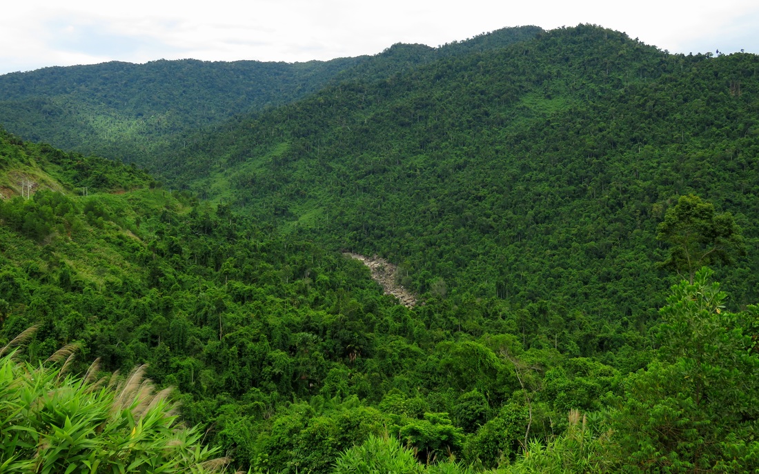
There may not be a single better view of so much raw, untouched virgin jungle in the entire Da Nang area. A single solitary road cuts deep into a large gorge in the mountains, built to reach a lonesome hydroelectric power plant found deep in the canyon bottom. The road to this is filled with countless views of this remote and unmolested canyon. The whole are might be one of the most remote areas around the entire city, despite being geographically not that far out there. There is little to say about this view; it is simply a place to stay awhile and soak in the raw immensity and majesty of the scene in front of you.
#1A (tie) - "Cha Val Overlook" - QL-14D - Nam Giang

#1B (tie) - Song Bung River Valley View - Nam Giang

These two views are about as good as it gets in central Vietnam, and this is thanks to the raw beauty of a place called Nam Giang. This wild chunk of mountains and river valleys is found in far western Quang Nam, and runs all the way to the border with Laos. These two views are very much worth the drive it takes to get to them. First is the view of the Cha Val area. Found a scant 25 km from the Lao border, the area around Cha Val town is a large, mostly-flat valley surrounded by high mountains on all sides. By driving up the "Cha Val Wall", a small range of mountains just north of the town, you can get a staggering view south over the valley itself, and down into the countless ridges of southern Nam Giang, which are some of the most wild areas left in Quang Nam. There are even unsubstantiated reports of tigers still prowling the area.
---
The second photo is looking over the valley of the Song Bung, or Stomach River, towards the valley of Cha Val in the distance. This view is just one of many along a remote road that leads to a village high in the mountains, and this one encapsulates everything that makes this drive and area so great: old growth forests of huge trees, stunning vistas that stretch on to the horizon, jungle-covered mountains, and a large river canyon in the bottom. You can tell how remote this second photo is by knowing that the farthest set of mountains you can see on the horizon are on the Vietnam-Laos border. Yep, it's that far out!
The Map
|
All photos copyright Kit Davidson.
All maps copyright Google MyMaps. |
